● Introduction:Geopolitics of Toponymic Inscription
“Just as none of us is outside or beyond geography, none of us is completely free from the struggle over geography. That struggle is complex and interesting because it is not only about soldiers and cannons but
also about ideas, about forms, about images and imaginings.”
— Edward Said in Culture and Imperialism (1994)
The quote by Said above accentuates that our human existence is dependent on geographical or territorial settings and the reprecussions that come with it. When individuals, communities or societies occupy a region of the earth, a territory, or a city, a plot of land, or when they follow routes, invest in them, or map them, they are not only claiming land but are highly involved in the
process of naming the globe — and by doing so owning and controlling the narratives of those environments. Depending on whether someone is a hunter-gatherer, farmer, navigator, merchant, conqueror, settler, dreamer, survivor,
engineer,
or administrator, this can take on quite various forms. Regardless of whether someone is colonizing a frontier, reclaiming ancestral lands or erasing symbols of authoritarian regimes, whether or not they speak a language with written
characters, the naming operation is never ultimate or exclusive; but it plays a key role in structuring reality (Giraut & Houssay-Holzschuch, 2022). Toponyms
Beside geographical features on the earth, the term ‘toponym’ also covers cosmographical features, i.e. all features in the observable universe. In this text, however, I use the ‘toponym’ only to refer to the
geographical features of our planet.
— also known as place names or geographical
names — play an important role in constructing historical memories, identifying the locations that are absorbed by those memories and granting them a tangible presence. They are a cultural element of shared public capital and
spatial infrastructure of our everyday life; they embody essential clues as to the historical and cultural heritage of geographical features of all kinds, whether they are constructed settlements like villages, cities, streets and
countries or natural places such as rivers, mountains or valleys (Kearns & Berg, 2002). One might say that every place name is a testimony of human life on earth, which carries
with it a history and meaning.
Toponyms are, however, not mere spatial signifiers; they hold a semantic depth profoundly rooted in power relations and struggles over land and resources and the identities of the inhabitants. When constructed through hegemonic
processes, they become intrinsically politico-territorial instruments for establishing spatial domination (Guyot & Seethal, 2007), drawing borders between “us” and “them” — the Self and the Other — in time and space (Marin, 2012). The naming of places is highly political, creating a hierarchy and affecting everyday life, identity, civil status, and location. It shapes individual and
collective relationships with places (Giraut & Houssay-Holzschuch, 2022). In nineteenth century European empire
building, the state authorities deployed renaming strategies to erase earlier political, social and cultural realities in order to invent traditions, reinforce ideologies and to construct new notions of national identity.
Transformations of toponyms often signify a societal shift and can therefore function as either unifying or dividing catalysts.
The present thesis is not meant to be an essay on place names (classical toponymy), and their etymological and taxonomical properties. Rather, it aims to offer a general and, possibly, holistic overview
of place naming (political toponymy), i.e. the geopolitically charged socio-spatial practice of toponymic inscription as a means to promote particular — and deny other — historical narratives and
conceptions of national identity and territorial reality. I will attempt to grasp the establishment and maintenance
of these structures and practices through decolonial, Marxist and feminist analytical frameworks. My point of departure is the Zionist political project of Hebraizing Arabic toponyms
in فلسطينPalestine as a mechanism for perpetual social production of displacement and replacement — an enterprise spanning from the late 19th-century
to the present day. The second chapter will focus on
role of cartography in the
demonstration of colonial discursive practices by looking at contemporary methods in map labeling and, in particular, the United Nations’ attempts to standardize geographical names to a Latinized form.
Although place naming is “a form of control or dispossession”, this domination “is rarely complete and can be challenged” (Alderman & Inwood, 2013). The toponymic landscape can thus serve as a site for challenging state authorities
and their hegemonic ideologies (Çakır, 2013). Resistance is often adversarial, but it can just as well be manifested in grass-root opposition and symbolic social acts, such as speech. The third and final chapter will hence deal with
subliminal counter-hegemonic acts in the everyday life of the subordinate.
I am writing this text primarily as a Graphic Designer — as someone who holds a certain level of agency in visual representations of our world — and as such, I regard this text as a research into my professional social
responsibilities and the role of a Graphic Designer as a communicator. I’m also writing from a privileged outsider position, as a white European male with a limited personal frame of reference and linguistic
comprehension. Thus, in writing this text, I’m solely relying on English-language literature and English translations of literature, which becomes somewhat paradoxical when dealing with the topic of linguistics — and even more so as I
speak of preservation of Arabic naming traditions. Despite the inevitable distortion of translation, I find including non-English-language bodies of work crucial in the project of destabilizing normative academic practices (i.e. the
use of English as the presiding language in research communication). Apart from being a widely researched, multifaceted example of an over century-long, and still very much active, form of cultural oppression, the choice of using the
contested history of the יִשְׂרָאֵלIsrael / فلسطينPalestine conflict
as my main case study also stems from a sense of urgency in bringing attention to the situation at hand. The conflict is anything but idle; with annually increasing settler attacks in
the occupied الضفة الغربيةWest Bank, the year 2022 was the deadliest for Palestinians in over 20 years
‘With 2022 Deadliest Year in Israel-Palestine Conflict, Reversing Violent Trends Must Be International Priority, Middle East Coordinator Tells Security Council’, United Nations, 18 January 2023
. Furthermore, Palestinians are currently living under the most far-right Israeli government to date, publicly announcing plans for expanded illegal settlements and other anti-Palestinian policies
‘Benjamin Netanyahu returns as PM of Israel’s most far-right gov’t’, Al Jazeera, 29 December 2022
, while European governments are pushing for further suppression of pro-Palestinian solidarity under the guise of antisemitism
‘Germany just took a drastic step toward criminalizing Palestine activism’, Nederlands Palestina Komitee, 21 December 2022
.
Although I have, as a member of the Swedish-speaking linguistic minority in SuomiFinland, experienced minor cultural marginalization, my life has by no means ever been marked by an oppressive apartheid regime, nor have I ever known racial
discrimination. I will thus attempt to express solidarity by reading across the lines of my own status. To quote writer and filmmaker Trinh T. Minh-ha: “I do not intend to speak about; just speak nearby.”
In Reassemblage (1982) by Trinh T. Minh-ha
● The CartographicCleansing of Palestine
“Nothing has affected the course of political events in the Middle East more than the Arab-Israeli conflict. The Zionist drive to establish a home for the Jews in فلسطينPalestine culminated in 1948 in the
dismemberment of the country and
the establishment of the state of יִשְׂרָאֵלIsrael. The events leading to this conclusion were characterized by political strife, military confrontations and demographic dislocation on a massive scale. Hundreds of thousands of Palestinians
(estimated amount around 700,000) were forced to leave their homes, to be replaced by waves of Jewish immigrants from all over the world. Some 150,000 Palestinians remained under Israeli rule. Almost overnight, the Palestinians in יִשְׂרָאֵלIsrael lost their majority status and found themselves a minority in their own country” (Suleiman, 2004).
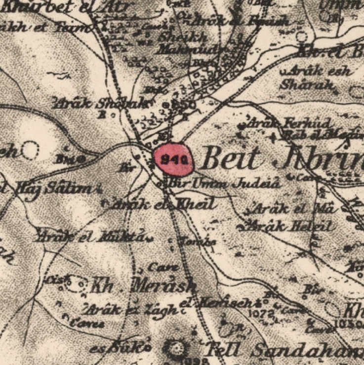
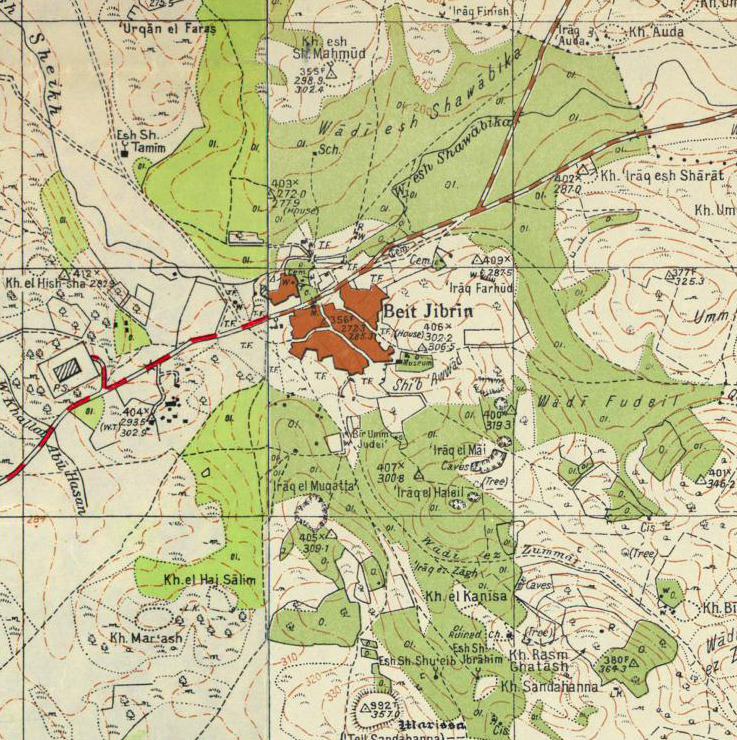
 Example of Hebraization of the depopulated Palestinian town Bayt Jibrin, demonstrated with maps from 1870s, 1940s and 2020 respectively. (Source: Palestine Open Maps)
Until today, the Israeli-Palestinian conflict remains a contested topic over which opinions are highly polarized. The ethnic cleansing of فلسطينPalestine in 1948 — commonly known as the Nakba (catastrophe)
It is fair, however, to question the adequacy of the term ‘Nakba’. Referring to the ethnic cleansing of
Palestine as a catastrophe or disaster suggests a sense of passivity. We regard earthquakes and tsunamis
as disasters, of which nobody is responsible for and everybody is a victim of. The same cannot be
said about the events of 1948—the ethnic cleansing was a crime; the roles of criminal and victim are
abundantly clear and know to us all. “Insisting on describing what happened to the Palestinians in
1948 and ever since as a crime and not just a tragedy or even a catastrophe is essential if past evils are
to be rectified” (Pappé, 2015).
— served
as a starting point for accelerated efforts to destroy the diverse cultural heritage of the land by the Israeli state; a toponymic project employing extensive memoricide
Memoricide: “The ‘erasure of the history of one people in order to write that of another people’s over it’, the continuous imposition of a Zionist layer and national pattern over everything that had been
Palestinian” (Pappé, 2006).
and linguistic dispossession. In a
systematic national effort, appointed by יִשְׂרָאֵלIsrael’s first Prime Minister David Ben Gurion, the state set to deepen the erasure of the Palestinian toponymic landscape — and subsequently collective memory — by Hebraizing Arabic place names and giving new settlements Biblical and Talmudic names; thus, transforming Zionism, from what began as a European national movement, into a colonialist one (Masalha, 2015; Dahamshe, 2021; Pappé, 2006). A 1992 study documented the
Hebraized names of about 2,780 historical locations, including 340 villages and towns, 1,000 ruins, 560 wadis
Alternatively wād — an Arabic term traditionally referring to a valley. In some instances, it may refer to a wet (ephemeral) riverbed that contains water only when heavy rain occurs.
and rivers, 380 springs, 198 mountains and hills, 50 caves, 28 castles and palaces, and 14 pools
and lakes (Amara, 2017). The production of a distinct Hebrew toponymy was conceived of and legitimized as a restorative measure and came to play a substantial part in the spatial history of modern יִשְׂרָאֵלIsrael, granting it
greater authenticity and fostering a broader national unity (Azaryahu & Golan, 2001). As suggested by Marcelo Svirsky (2010), we can begin to understand the way in which the Zionist fabric has developed the Palestinian entity by
examining how the Zionists view and position themselves in relation to Palestinians and their land.
● Territorial Entitlement
The concept of the (constitutive) Other — coined by Hegel in the late 18th-century
Further developed by Husserl, Lacan, Levinas, Sartre and de Beauvoir among others.
— identifies the other human being in their state of being different from the social identity of the Self (Borchert, 1967; Said, 1978). Labeling a person as the Other pushes them away from the mainstream of society and relegates them to the margins. In postcolonial studies, the term subaltern, coined by the Italian Marxist theorist Antonio Gramsci, identifies the cultural hegemony that excludes and displaces specific people and
social groups from
socio-economic institutions of society in order to deny their agency and voices in colonial politics (Ludden, 2002). The following section will focus on the problem of the disappearance of the subaltern
in the context of the
colonial concept of Terra Nullius, seen as a continuous social production of collective displacement and replacement within a specific form of settler-colonialism — Zionism.
Traditionally, in European colonial history, authority was generally supported by an ideology of cultural supremacy; in Zionism, however, it was accompanied by redemptive nationalism.
The Latin expression Terra Nullius (meaning “nobody’s land”) is a colonial and ideological concept that perceives land as formally unoccupied. The doctrine has served colonizers throughout history by
legitimizing and morally justifying the sovereignty over a given territory upon conquest or settlement. Due to the absence of institutions and western agricultural practices, European colonizers claimed that “the indigenous
inhabitants were not sufficiently settled or had not tilled the land in a manner that made them rightful owners” (Patton, 2000), thus expanding the meaning of Terra Nullius to include territories
considered ‘devoid of civilized society’ (Svirsky, 2010). The approach to treat inhabitants as non-civil or undereducated is part of the settler’s and colonialist’s strategy itself. It creates a means to justify the arrival of a
colonial power or a settler in the first place.
Example of Hebraization of the depopulated Palestinian town Bayt Jibrin, demonstrated with maps from 1870s, 1940s and 2020 respectively. (Source: Palestine Open Maps)
Until today, the Israeli-Palestinian conflict remains a contested topic over which opinions are highly polarized. The ethnic cleansing of فلسطينPalestine in 1948 — commonly known as the Nakba (catastrophe)
It is fair, however, to question the adequacy of the term ‘Nakba’. Referring to the ethnic cleansing of
Palestine as a catastrophe or disaster suggests a sense of passivity. We regard earthquakes and tsunamis
as disasters, of which nobody is responsible for and everybody is a victim of. The same cannot be
said about the events of 1948—the ethnic cleansing was a crime; the roles of criminal and victim are
abundantly clear and know to us all. “Insisting on describing what happened to the Palestinians in
1948 and ever since as a crime and not just a tragedy or even a catastrophe is essential if past evils are
to be rectified” (Pappé, 2015).
— served
as a starting point for accelerated efforts to destroy the diverse cultural heritage of the land by the Israeli state; a toponymic project employing extensive memoricide
Memoricide: “The ‘erasure of the history of one people in order to write that of another people’s over it’, the continuous imposition of a Zionist layer and national pattern over everything that had been
Palestinian” (Pappé, 2006).
and linguistic dispossession. In a
systematic national effort, appointed by יִשְׂרָאֵלIsrael’s first Prime Minister David Ben Gurion, the state set to deepen the erasure of the Palestinian toponymic landscape — and subsequently collective memory — by Hebraizing Arabic place names and giving new settlements Biblical and Talmudic names; thus, transforming Zionism, from what began as a European national movement, into a colonialist one (Masalha, 2015; Dahamshe, 2021; Pappé, 2006). A 1992 study documented the
Hebraized names of about 2,780 historical locations, including 340 villages and towns, 1,000 ruins, 560 wadis
Alternatively wād — an Arabic term traditionally referring to a valley. In some instances, it may refer to a wet (ephemeral) riverbed that contains water only when heavy rain occurs.
and rivers, 380 springs, 198 mountains and hills, 50 caves, 28 castles and palaces, and 14 pools
and lakes (Amara, 2017). The production of a distinct Hebrew toponymy was conceived of and legitimized as a restorative measure and came to play a substantial part in the spatial history of modern יִשְׂרָאֵלIsrael, granting it
greater authenticity and fostering a broader national unity (Azaryahu & Golan, 2001). As suggested by Marcelo Svirsky (2010), we can begin to understand the way in which the Zionist fabric has developed the Palestinian entity by
examining how the Zionists view and position themselves in relation to Palestinians and their land.
● Territorial Entitlement
The concept of the (constitutive) Other — coined by Hegel in the late 18th-century
Further developed by Husserl, Lacan, Levinas, Sartre and de Beauvoir among others.
— identifies the other human being in their state of being different from the social identity of the Self (Borchert, 1967; Said, 1978). Labeling a person as the Other pushes them away from the mainstream of society and relegates them to the margins. In postcolonial studies, the term subaltern, coined by the Italian Marxist theorist Antonio Gramsci, identifies the cultural hegemony that excludes and displaces specific people and
social groups from
socio-economic institutions of society in order to deny their agency and voices in colonial politics (Ludden, 2002). The following section will focus on the problem of the disappearance of the subaltern
in the context of the
colonial concept of Terra Nullius, seen as a continuous social production of collective displacement and replacement within a specific form of settler-colonialism — Zionism.
Traditionally, in European colonial history, authority was generally supported by an ideology of cultural supremacy; in Zionism, however, it was accompanied by redemptive nationalism.
The Latin expression Terra Nullius (meaning “nobody’s land”) is a colonial and ideological concept that perceives land as formally unoccupied. The doctrine has served colonizers throughout history by
legitimizing and morally justifying the sovereignty over a given territory upon conquest or settlement. Due to the absence of institutions and western agricultural practices, European colonizers claimed that “the indigenous
inhabitants were not sufficiently settled or had not tilled the land in a manner that made them rightful owners” (Patton, 2000), thus expanding the meaning of Terra Nullius to include territories
considered ‘devoid of civilized society’ (Svirsky, 2010). The approach to treat inhabitants as non-civil or undereducated is part of the settler’s and colonialist’s strategy itself. It creates a means to justify the arrival of a
colonial power or a settler in the first place.
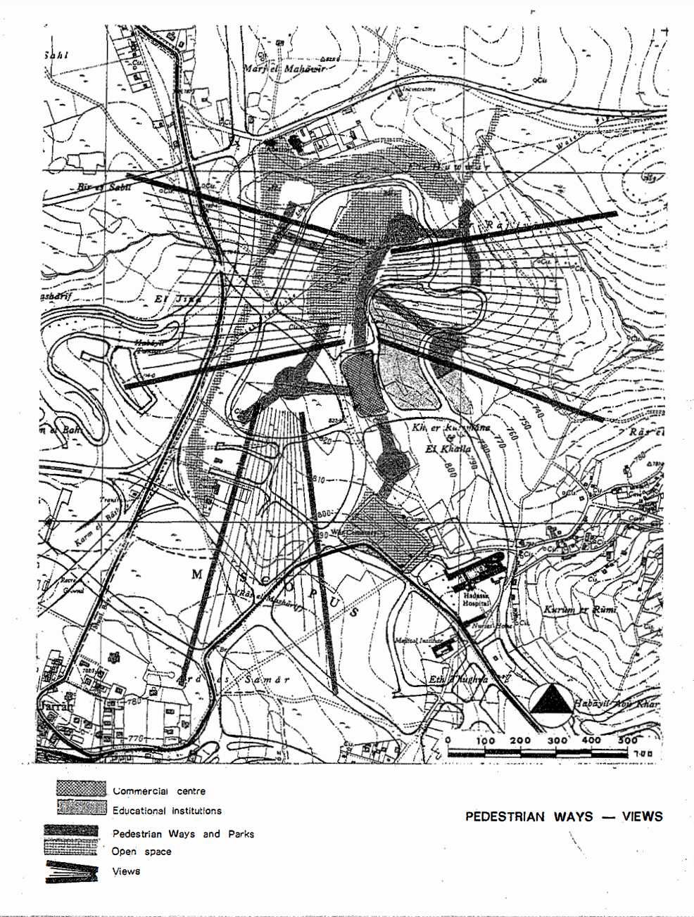 Study Drawing of the Jerusalem neighbourhood of French Hill. Israeli settlements in the West Bank and East Jerusalem are often located on hilltops and offer commanding views of the surrounding area. The Israeli military uses these
settlements as surveillance outposts to monitor Palestinian activity. (Source: Eyal Weizman/Israel Builds, Ministry of Construction and Housing, 1972)
In his book Hollow Land: Israel's Architecture of Occupation, architect Eyal Weizman examines the role of architecture and urban planning in the Israeli-Palestinian conflict, and shows how these fields
have been used to maintain and reinforce the colonial relationship between the Israeli state and the Palestinian people. He argues that the architecture of the Occupied Territories serves as a tool of control and domination, and
perpetuates the idea of Terra Nullius by erasing the presence of Palestinians and replacing it with a vision of an uninhabited land waiting to be redeemed by the Israeli settlers. By exploring the ways
in which architecture and urban planning contribute to the maintenance of the colonial relationship, Weizman offers a nuanced analysis of the impact of colonial discourse on the subaltern, and the ways
in which it is perpetuated through the built environment (Weizman, 2007).
Although the term Terra Nullius was not specifically used in the colonial discourse of Zionists, we can find several analogous phrases in Zionist mythology suggesting notions of uninhabited lands,
such as: ‘making the desert bloom’; the ‘conquest of the land’; and ‘land redemption.’ These mythical tools function as “cultural representations and disciplinary devices aimed at rallying the population behind the cause of an
historical enterprise” (Svirsky, 2010). Dalsheim (2004) identifies denial and memoricide as ingredients of the Zionist practice by arguing that Terra Nullius “encapsulates a fantasy, a product of a
nationalist imagination, a way of thinking that fundamentally gives rise to ‘a longing to be rid of those who were never fully known’.” In Althusserian terms, state apparatuses are not limited to repressive methods, i.e. enforcing
direct force and political control; they are furthermore fundamentally ideological, invoking specific ways of viewing the world, identities, relationships with other individuals, and their connections to society (Wolff, 2004). In
this respect, Terra Nullius serves as a construction that illustrates how Israeli Jews represent themselves to themselves; the desired absence of Palestinians erases and reconstructs the past and
memory through mental acts of self-deception. How does one, then, manage to forget intentionally what one really believes?
Self-deception constitutes of inevitably paradoxical lines of thought. As Elster (1983) remarks: “By wanting the non-existence of the object, one confers existence of it.” In other words, the Self
cannot exist without its vital counterpart — the Other; and the Zionists’ mission to erase the memory of the ethnic cleansing of 1948 ensures the very presence of that memory. This is where
discursive concepts such as Terra Nullius come in handy. The unpleasant awareness of past wrongdoings is consciously rejected and replaced by a psychological mechanism that reconciles and ameliorates
the wrong (Svirsky, 2010).
This analysis of the concept of Terra Nullius in the context of Zionism, however,
only scrapes the surface of the subaltern’s experience. Gayatri Spivak's seminal essay
Can the Subaltern Speak? critiques the limitations of postcolonial theory by highlighting
the ways in which dominant (Western academic) discourses of power restrict the
ability of the subaltern to fully express themselves. Spivak argues that the subaltern
are rendered voiceless and invisible by the very structures of power that oppress them,
making it impossible for them to speak within dominant discourses. Instead, she calls
for a deeper engagement with “their lived experiences and the complex ways in which
they have been shaped by imperialism […] and an attempt to understand the subaltern
on their own terms, rather than imposing our own frameworks and categories onto
them” (Spivak, 1988).
● The Cultural Arena
The names of places belong to the language of nationalism. Especially in areas where national or ethnic identities are contested, co-existing toponymies “compete for being recognized as legitimate and definitive,” and the existence
and use — and correspondingly rejection — of place names become inherent features of conflict, as they concretize abstract arguments over historical and territorial claims (Azaryahu & Golan, 2001). The Zionist awareness of the
political power of the map as a model for nation building — for mapping the national Self and unmapping the Other — was apparent since the early days of the British mandate
in فلسطينPalestine. The Jewish members on the Geographical Committee for Names in Palestine
Committee operating under the Royal Geographical Society, the only body authorized to assign names throughout the British Empire, including Mandatory Palestine.
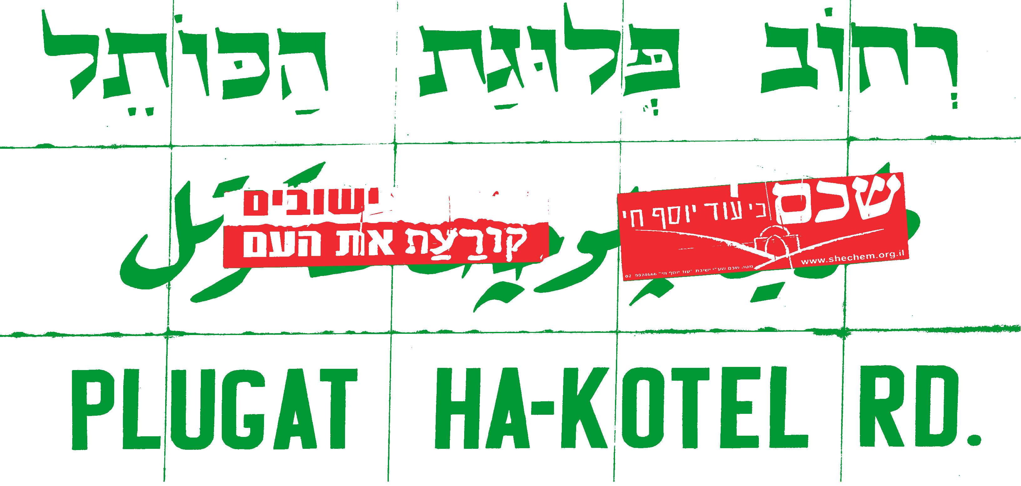
were in strong opposition towards the use of Arabic names, such as نابلسNablus instead of שכםShechem or الخليKhalil instead of חֶבְרוֹןHebron or
القُدسal-Quds instead of יְרוּשָׁלַיִםJerusalem, on official maps
produced by the Survey of Palestine
Survey of Palestine was the government department responsible for the survey and mapping of Palestine during the British mandate period (1920–1948).
, viewing this as anti-Jewish discrimination. The toponymic landscape became an ideological battleground — a cultural arena — and the Zionists’ attitudes clearly reflected the role of the map “as a model for, rather than a model of the landscape” in the framework of Zionist ideology (Suleiman, 2004).
This mentality gained momentum in 1949, four months after יִשְׂרָאֵלIsrael’s occupation of the ٱلنَّقَبNegev
A vast desert region in the southern part of present-day Israel.
, when Prime Minister Ben Gurion established the Negev Names Committee (NNC) and gave it the task of assigning “Hebrew names to all the places — mountains, valleys springs, roads and so on — in the Negev region” (Benvenisti,
2000). Ben Gurion’s instructions to the NNC left no space for misunderstandings: “We are obliged to remove the Arabic names for reasons of state. Just as we do not recognize the Arabs’ political proprietorship of the land, so also do
we not recognize their spiritual proprietorship and their names” (cited in Benvenisti, 2000). The members of the committee were fully aware that they were not merely carrying out a technical exercise or work of research in their field
of endeavor — it was an act of paramount political significance and symbolic appropriation; the concretization of Jewish proprietorship for more than half of יִשְׂרָאֵלIsrael’s newly conquered territory (Benvenisti, 2000).
Study Drawing of the Jerusalem neighbourhood of French Hill. Israeli settlements in the West Bank and East Jerusalem are often located on hilltops and offer commanding views of the surrounding area. The Israeli military uses these
settlements as surveillance outposts to monitor Palestinian activity. (Source: Eyal Weizman/Israel Builds, Ministry of Construction and Housing, 1972)
In his book Hollow Land: Israel's Architecture of Occupation, architect Eyal Weizman examines the role of architecture and urban planning in the Israeli-Palestinian conflict, and shows how these fields
have been used to maintain and reinforce the colonial relationship between the Israeli state and the Palestinian people. He argues that the architecture of the Occupied Territories serves as a tool of control and domination, and
perpetuates the idea of Terra Nullius by erasing the presence of Palestinians and replacing it with a vision of an uninhabited land waiting to be redeemed by the Israeli settlers. By exploring the ways
in which architecture and urban planning contribute to the maintenance of the colonial relationship, Weizman offers a nuanced analysis of the impact of colonial discourse on the subaltern, and the ways
in which it is perpetuated through the built environment (Weizman, 2007).
Although the term Terra Nullius was not specifically used in the colonial discourse of Zionists, we can find several analogous phrases in Zionist mythology suggesting notions of uninhabited lands,
such as: ‘making the desert bloom’; the ‘conquest of the land’; and ‘land redemption.’ These mythical tools function as “cultural representations and disciplinary devices aimed at rallying the population behind the cause of an
historical enterprise” (Svirsky, 2010). Dalsheim (2004) identifies denial and memoricide as ingredients of the Zionist practice by arguing that Terra Nullius “encapsulates a fantasy, a product of a
nationalist imagination, a way of thinking that fundamentally gives rise to ‘a longing to be rid of those who were never fully known’.” In Althusserian terms, state apparatuses are not limited to repressive methods, i.e. enforcing
direct force and political control; they are furthermore fundamentally ideological, invoking specific ways of viewing the world, identities, relationships with other individuals, and their connections to society (Wolff, 2004). In
this respect, Terra Nullius serves as a construction that illustrates how Israeli Jews represent themselves to themselves; the desired absence of Palestinians erases and reconstructs the past and
memory through mental acts of self-deception. How does one, then, manage to forget intentionally what one really believes?
Self-deception constitutes of inevitably paradoxical lines of thought. As Elster (1983) remarks: “By wanting the non-existence of the object, one confers existence of it.” In other words, the Self
cannot exist without its vital counterpart — the Other; and the Zionists’ mission to erase the memory of the ethnic cleansing of 1948 ensures the very presence of that memory. This is where
discursive concepts such as Terra Nullius come in handy. The unpleasant awareness of past wrongdoings is consciously rejected and replaced by a psychological mechanism that reconciles and ameliorates
the wrong (Svirsky, 2010).
This analysis of the concept of Terra Nullius in the context of Zionism, however,
only scrapes the surface of the subaltern’s experience. Gayatri Spivak's seminal essay
Can the Subaltern Speak? critiques the limitations of postcolonial theory by highlighting
the ways in which dominant (Western academic) discourses of power restrict the
ability of the subaltern to fully express themselves. Spivak argues that the subaltern
are rendered voiceless and invisible by the very structures of power that oppress them,
making it impossible for them to speak within dominant discourses. Instead, she calls
for a deeper engagement with “their lived experiences and the complex ways in which
they have been shaped by imperialism […] and an attempt to understand the subaltern
on their own terms, rather than imposing our own frameworks and categories onto
them” (Spivak, 1988).
● The Cultural Arena
The names of places belong to the language of nationalism. Especially in areas where national or ethnic identities are contested, co-existing toponymies “compete for being recognized as legitimate and definitive,” and the existence
and use — and correspondingly rejection — of place names become inherent features of conflict, as they concretize abstract arguments over historical and territorial claims (Azaryahu & Golan, 2001). The Zionist awareness of the
political power of the map as a model for nation building — for mapping the national Self and unmapping the Other — was apparent since the early days of the British mandate
in فلسطينPalestine. The Jewish members on the Geographical Committee for Names in Palestine
Committee operating under the Royal Geographical Society, the only body authorized to assign names throughout the British Empire, including Mandatory Palestine.
were in strong opposition towards the use of Arabic names, such as نابلسNablus instead of שכםShechem or الخليKhalil instead of חֶבְרוֹןHebron or
القُدسal-Quds instead of יְרוּשָׁלַיִםJerusalem, on official maps
produced by the Survey of Palestine
Survey of Palestine was the government department responsible for the survey and mapping of Palestine during the British mandate period (1920–1948).
, viewing this as anti-Jewish discrimination. The toponymic landscape became an ideological battleground — a cultural arena — and the Zionists’ attitudes clearly reflected the role of the map “as a model for, rather than a model of the landscape” in the framework of Zionist ideology (Suleiman, 2004).
This mentality gained momentum in 1949, four months after יִשְׂרָאֵלIsrael’s occupation of the ٱلنَّقَبNegev
A vast desert region in the southern part of present-day Israel.
, when Prime Minister Ben Gurion established the Negev Names Committee (NNC) and gave it the task of assigning “Hebrew names to all the places — mountains, valleys springs, roads and so on — in the Negev region” (Benvenisti,
2000). Ben Gurion’s instructions to the NNC left no space for misunderstandings: “We are obliged to remove the Arabic names for reasons of state. Just as we do not recognize the Arabs’ political proprietorship of the land, so also do
we not recognize their spiritual proprietorship and their names” (cited in Benvenisti, 2000). The members of the committee were fully aware that they were not merely carrying out a technical exercise or work of research in their field
of endeavor — it was an act of paramount political significance and symbolic appropriation; the concretization of Jewish proprietorship for more than half of יִשְׂרָאֵלIsrael’s newly conquered territory (Benvenisti, 2000).
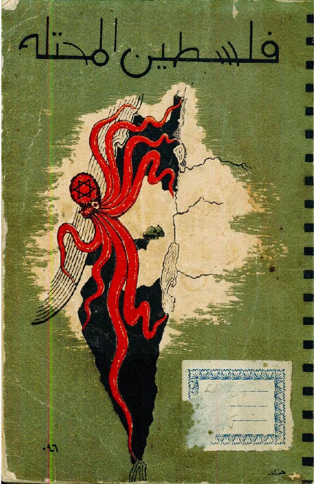 This map appeared on the back cover of the 1952 anonymous book titled Occupied Palestine (Filastin al-Muhtalla). The cartographer depicted the State of Israel as an octopus, extending its arms to all four corners of Palestine. The
West Bank and Gaza are shaded white.(Source: http://www.midafternoonmap.com)
Ironically, out of the 533 names the NNC had assigned by the time it concluded its work in March 1951, 333 were either translations of, or based on phonetic similarity to the Arabic names they replaced. The committee justified this by
arguing that the Arabic names originally derived from ancient Hebrew names and the act of renaming allowed them to ‘redeem’ the places in question from ‘corrupt’ Arabic names (Kadman, 2015; Suleiman, 2004). The names, used by the
Bedouin of the ٱلنَّقَبNegev for centuries, were erased from the official Hebrew maps, and subsequently from road signs, newspapers, guidebooks and geography texts (Benvenisti, 2000). With this ‘purification’, an entire world of cultural
memories and traditions vanished; expelled by force, just like the Palestinian Bedouin who used to roam the land.
In 1951 the same blueprint was applied to the rest of the country. An official map for civilian use, that included the Hebrew names of the new Israeli settlements, was produced in 1958
This map was based on the 1:100 000 map prepared by the British mandate government in 1942. The official place names of Mandatory Palestine were mainly Arabic or relating to Christian traditions, rendering them
foreign from the perspective of Jewish nationalism and the Zionist project (Azaryahu and Golan, 2001).
. The more than 400 Arab villages that had been destroyed since 1948 were preserved on the map with the addition of the Hebrew word ‘הָרוּס’ (destroyed) next to the names. The map thus served as a
palpable record of the Nakba, the dismemberment of فلسطينPalestine and the establishment of יִשְׂרָאֵלIsrael. “By removing most of the Arabic place names from the map,” Professor Yasir Suleiman writes, “Israel did not just create a new map, it also
inscribed a new reality in which Hebrew won the battle over Arabic, just as early Zionists hoped it would. […] The elimination of Arabic place names from the map has also caused the loss of a set of meanings and traditions that
express the connection of the Palestinians to the land” (Suleiman, 2004). A closer look at these toponymies reveals their abundance in conceptualizations and images that shed light on the different ways Palestinian and Israeli
cultures view nature.
Herewith, we also come to understand that the occupation of places is incomplete without memory and linguistic occupation. The act of colonization begins with strategic acts of linguicism — the systematic erasure of language
culminating in discursive invisibility.
This map appeared on the back cover of the 1952 anonymous book titled Occupied Palestine (Filastin al-Muhtalla). The cartographer depicted the State of Israel as an octopus, extending its arms to all four corners of Palestine. The
West Bank and Gaza are shaded white.(Source: http://www.midafternoonmap.com)
Ironically, out of the 533 names the NNC had assigned by the time it concluded its work in March 1951, 333 were either translations of, or based on phonetic similarity to the Arabic names they replaced. The committee justified this by
arguing that the Arabic names originally derived from ancient Hebrew names and the act of renaming allowed them to ‘redeem’ the places in question from ‘corrupt’ Arabic names (Kadman, 2015; Suleiman, 2004). The names, used by the
Bedouin of the ٱلنَّقَبNegev for centuries, were erased from the official Hebrew maps, and subsequently from road signs, newspapers, guidebooks and geography texts (Benvenisti, 2000). With this ‘purification’, an entire world of cultural
memories and traditions vanished; expelled by force, just like the Palestinian Bedouin who used to roam the land.
In 1951 the same blueprint was applied to the rest of the country. An official map for civilian use, that included the Hebrew names of the new Israeli settlements, was produced in 1958
This map was based on the 1:100 000 map prepared by the British mandate government in 1942. The official place names of Mandatory Palestine were mainly Arabic or relating to Christian traditions, rendering them
foreign from the perspective of Jewish nationalism and the Zionist project (Azaryahu and Golan, 2001).
. The more than 400 Arab villages that had been destroyed since 1948 were preserved on the map with the addition of the Hebrew word ‘הָרוּס’ (destroyed) next to the names. The map thus served as a
palpable record of the Nakba, the dismemberment of فلسطينPalestine and the establishment of יִשְׂרָאֵלIsrael. “By removing most of the Arabic place names from the map,” Professor Yasir Suleiman writes, “Israel did not just create a new map, it also
inscribed a new reality in which Hebrew won the battle over Arabic, just as early Zionists hoped it would. […] The elimination of Arabic place names from the map has also caused the loss of a set of meanings and traditions that
express the connection of the Palestinians to the land” (Suleiman, 2004). A closer look at these toponymies reveals their abundance in conceptualizations and images that shed light on the different ways Palestinian and Israeli
cultures view nature.
Herewith, we also come to understand that the occupation of places is incomplete without memory and linguistic occupation. The act of colonization begins with strategic acts of linguicism — the systematic erasure of language
culminating in discursive invisibility.
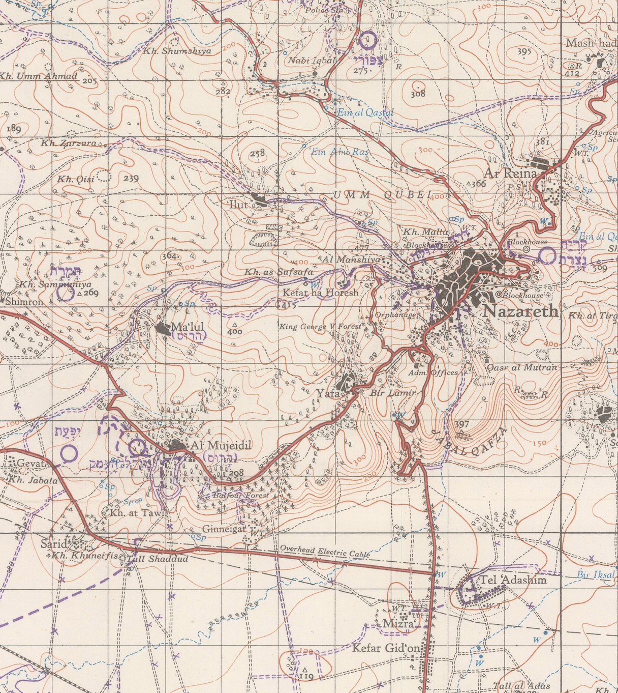
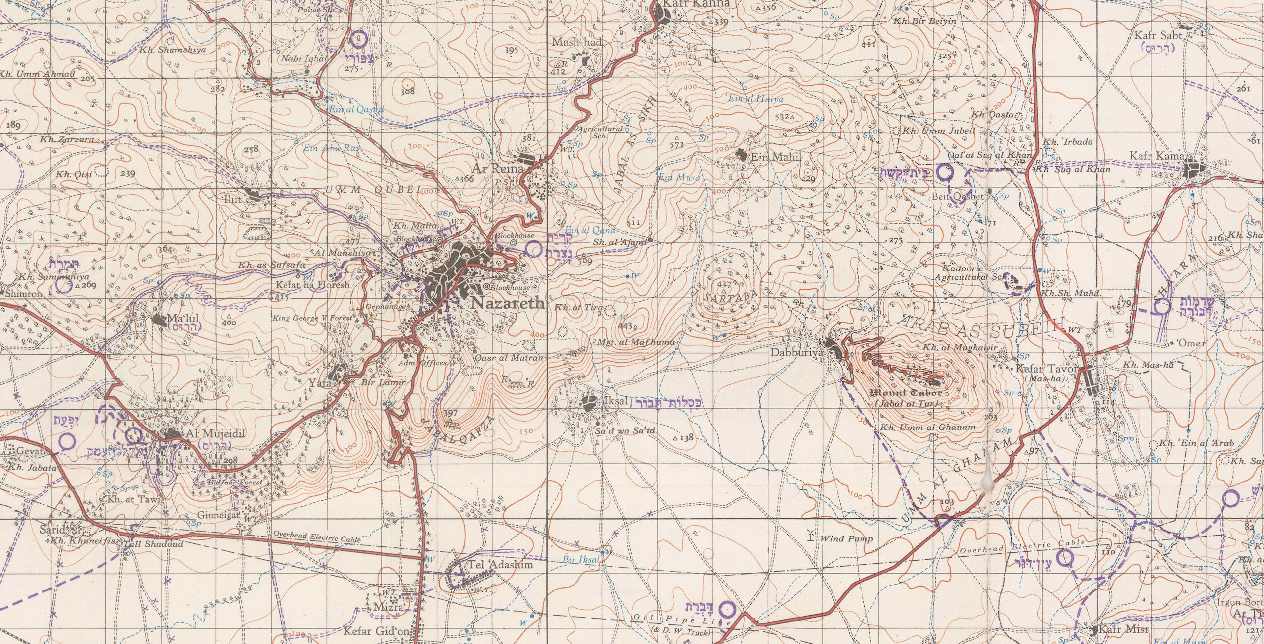 A portion of a map reproduced by the Israeli survey department in 1958. Note the English transcription of Arab and Jewish place names, and the purple Hebrew overprint that marks destruction of Palestinian
villages, including Maʿlul, and names of new Jewish settlements established since 1948. (Source: Palestine Open Maps)
● A Comparative Reading of Palestinian and Israeli Toponyms
“The wealth of Arabic toponymy is astounding in its beauty, its sensitivity to the landscape, its delicacy of observation and choice of images. Its metaphors have a poetic quality; its humor is sometimes refined,
sometimes sarcastic. The knowledge of the climate, the familiarity with nature and inanimate objects is absolute.”
— Meron Benvenisti in Sacred Landscape (2000)
In the following section, due to my unfamiliarity with the Arabic and Hebrew languages and scripts, I have relied heavily on the comparative readings of Arabic and Hebrew toponyms brilliantly conducted by Professor Nur Masalha (2015),
Dr. Amer Dahamshe (2021) and Meron Benvenisti (2000), in order to shed light on the socio-, ethno-, and psycholinguistic considerations related to the different spatial thinking of Israelis and Palestinians. Dahamshe identifies five
analytical categories in the Zionist renaming process: unification, uniqueness, masculine rhetoric, sanitation and linguistic mimicry.
Unification refers to the standardization of names, disregarding indigenous concepts. For example, the Hebrew name for the wadi נחל יפתחאלNaḥal Yiftaḥel covers 24 km of the river and its two tributaries, while in Arabic, six different names are used to refer to the same river; وادي المَعاصِرWādī al-Maʿaṣir (Wine Press River) and وادي المُغُرWādī al-Mughr (Cave River) are the names of the two tributaries; the sections of the main river are called وادي الجَرْبانWādī Jaraban — after the river’s ugly and uneven shape
that resembles the skin of those afflicted with eczema; وادي الأَعوجWādī al-Aawaj (Winding River); وادي رمّانِةWādī Rumanah, after the nearby village; and وادي الخالديّةWādī al-Khaladiyya, after a seasonal Bedouin encampment. These names reveal the familiar and intimate contact between Palestinians and their surroundings.
Uniqueness refers to using a single name to signify a single feature. In Arabic, the same word is often used for a number of features. For instance, the name عين التينةʿAyn al-Tīneh — which stems from the presence of nearby fig trees — is a reoccurring name for springs and rivers, which have been Hebraized as, for example, עין כנרʿEin Kaner, עין פאג'רʿEin Pagah, עין יקיםʿEin Yaqim and נחל מירוןNaḥal Miron. These strategies function as a means of surveillance and are employed by the Zionists to essentially serve economic and political purposes.
The pre-1948 Palestinian geographical space had significant representations of Palestinian women and their folklore. Zionist renaming practices have constituted gendered power relations by diminishing the female subject and feminine
connotations and replacing them with masculine rhetoric and patriarchal conventions; names of Palestinian women were replaced by Hebrew male names. For example, عين أم القصبWādī Umm al-Kaṣab (River of the Mother of the Reeds) was renamed נחל אלוןNaḥal Alon (Oak River, ‘oak’ being a masculine noun), and عين اُم حامدʿAyn Umm Ḥamid (Spring of Hamid’s Mother) became עין חומתʿEin Ḥomeṭ (which refers to a
male lizard). It is also worth mentioning that in the rhetoric of Zionist colonization as well as in Hebrew literature, settling a territory is often described as a form of sexual act, particularly between a man and a ‘virgin land’ (Rogani, 2009).
Sanitation refers to replacing Palestinian names perceived by the Zionists as ‘wild’ and ‘inappropriate’. As we have already concluded, the Palestinians are intimately familiar with their surroundings,
including their harsh and threatening aspects. وادي المجنونةWādī al-Majnunah (Madwoman River), referring to the irregular flow of the river and the intensive pulses that caused great damage to the surrounding
agricultural lands, driving the landowners mad, was replaced by נחל בית העמקNaḥal Beit Haʿemeḳ, referring to a nearby kibbutz, while وادي المدبىWādī al-Maḍabiʿ (Hyena River) became נחל צוייהNaḥal Tzviyah (Gazelle River). These ‘inappropriate’ names also served as evidence for the Zionists of the Palestinians’ inability to tame the forces of nature and cultivate the land, further
justifying the mission of ‘making the desert bloom’.
There is, however, a certain ambivalence in the Zionists’ renaming practices. Despite going through extreme lengths to erase the Palestinians’ historical and national attachment to the land, numerous orthographic elements of Arabic
names have been retained in the Hebraized forms through linguistic mimicry. These acts can take shape as direct translations — such as جبل السويديJabal al-Suwaydi being directly
translated to הר שחורתHar Shiḥoret (both meaning ‘Black Mountain’) — or based on phonetic or morphological similarity — such as عين أم طمرونʿAyn Umm Ṭamrun becoming עין טמירʿEin Ṭamir, or وادي العسلʿAyn al-ʿAsal becoming עין אסלʿEin Esel.
We thus come to realize that despite the extremely complex perspectives involved in the Zionists’ (rather arbitrary) renaming project, its main objective is to deny the role of the Palestinian names as linguistic vessels carrying
history, culture and memory.
A portion of a map reproduced by the Israeli survey department in 1958. Note the English transcription of Arab and Jewish place names, and the purple Hebrew overprint that marks destruction of Palestinian
villages, including Maʿlul, and names of new Jewish settlements established since 1948. (Source: Palestine Open Maps)
● A Comparative Reading of Palestinian and Israeli Toponyms
“The wealth of Arabic toponymy is astounding in its beauty, its sensitivity to the landscape, its delicacy of observation and choice of images. Its metaphors have a poetic quality; its humor is sometimes refined,
sometimes sarcastic. The knowledge of the climate, the familiarity with nature and inanimate objects is absolute.”
— Meron Benvenisti in Sacred Landscape (2000)
In the following section, due to my unfamiliarity with the Arabic and Hebrew languages and scripts, I have relied heavily on the comparative readings of Arabic and Hebrew toponyms brilliantly conducted by Professor Nur Masalha (2015),
Dr. Amer Dahamshe (2021) and Meron Benvenisti (2000), in order to shed light on the socio-, ethno-, and psycholinguistic considerations related to the different spatial thinking of Israelis and Palestinians. Dahamshe identifies five
analytical categories in the Zionist renaming process: unification, uniqueness, masculine rhetoric, sanitation and linguistic mimicry.
Unification refers to the standardization of names, disregarding indigenous concepts. For example, the Hebrew name for the wadi נחל יפתחאלNaḥal Yiftaḥel covers 24 km of the river and its two tributaries, while in Arabic, six different names are used to refer to the same river; وادي المَعاصِرWādī al-Maʿaṣir (Wine Press River) and وادي المُغُرWādī al-Mughr (Cave River) are the names of the two tributaries; the sections of the main river are called وادي الجَرْبانWādī Jaraban — after the river’s ugly and uneven shape
that resembles the skin of those afflicted with eczema; وادي الأَعوجWādī al-Aawaj (Winding River); وادي رمّانِةWādī Rumanah, after the nearby village; and وادي الخالديّةWādī al-Khaladiyya, after a seasonal Bedouin encampment. These names reveal the familiar and intimate contact between Palestinians and their surroundings.
Uniqueness refers to using a single name to signify a single feature. In Arabic, the same word is often used for a number of features. For instance, the name عين التينةʿAyn al-Tīneh — which stems from the presence of nearby fig trees — is a reoccurring name for springs and rivers, which have been Hebraized as, for example, עין כנרʿEin Kaner, עין פאג'רʿEin Pagah, עין יקיםʿEin Yaqim and נחל מירוןNaḥal Miron. These strategies function as a means of surveillance and are employed by the Zionists to essentially serve economic and political purposes.
The pre-1948 Palestinian geographical space had significant representations of Palestinian women and their folklore. Zionist renaming practices have constituted gendered power relations by diminishing the female subject and feminine
connotations and replacing them with masculine rhetoric and patriarchal conventions; names of Palestinian women were replaced by Hebrew male names. For example, عين أم القصبWādī Umm al-Kaṣab (River of the Mother of the Reeds) was renamed נחל אלוןNaḥal Alon (Oak River, ‘oak’ being a masculine noun), and عين اُم حامدʿAyn Umm Ḥamid (Spring of Hamid’s Mother) became עין חומתʿEin Ḥomeṭ (which refers to a
male lizard). It is also worth mentioning that in the rhetoric of Zionist colonization as well as in Hebrew literature, settling a territory is often described as a form of sexual act, particularly between a man and a ‘virgin land’ (Rogani, 2009).
Sanitation refers to replacing Palestinian names perceived by the Zionists as ‘wild’ and ‘inappropriate’. As we have already concluded, the Palestinians are intimately familiar with their surroundings,
including their harsh and threatening aspects. وادي المجنونةWādī al-Majnunah (Madwoman River), referring to the irregular flow of the river and the intensive pulses that caused great damage to the surrounding
agricultural lands, driving the landowners mad, was replaced by נחל בית העמקNaḥal Beit Haʿemeḳ, referring to a nearby kibbutz, while وادي المدبىWādī al-Maḍabiʿ (Hyena River) became נחל צוייהNaḥal Tzviyah (Gazelle River). These ‘inappropriate’ names also served as evidence for the Zionists of the Palestinians’ inability to tame the forces of nature and cultivate the land, further
justifying the mission of ‘making the desert bloom’.
There is, however, a certain ambivalence in the Zionists’ renaming practices. Despite going through extreme lengths to erase the Palestinians’ historical and national attachment to the land, numerous orthographic elements of Arabic
names have been retained in the Hebraized forms through linguistic mimicry. These acts can take shape as direct translations — such as جبل السويديJabal al-Suwaydi being directly
translated to הר שחורתHar Shiḥoret (both meaning ‘Black Mountain’) — or based on phonetic or morphological similarity — such as عين أم طمرونʿAyn Umm Ṭamrun becoming עין טמירʿEin Ṭamir, or وادي العسلʿAyn al-ʿAsal becoming עין אסלʿEin Esel.
We thus come to realize that despite the extremely complex perspectives involved in the Zionists’ (rather arbitrary) renaming project, its main objective is to deny the role of the Palestinian names as linguistic vessels carrying
history, culture and memory.
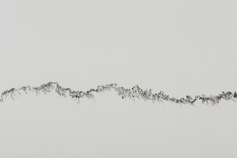
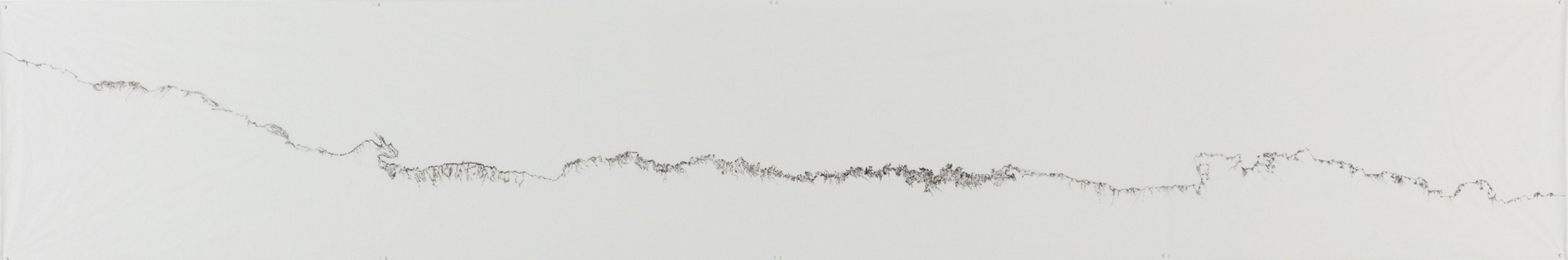 Saba Innab Untitled (Map) (2012) from From "How to Build Without a Land" (2011-ongoing)(Source: Saba Innab)
● A Rose by Any Other Name Would Smell as Sweet?
Professors Maoz Azaryahu and Arnon Golan (2001) describe the purpose of the map to be an “objective and definitive representation of the landscape, and their authority is conductive to the substantialization of place names as an
aspect of the landscape and to rendering a specific toponymy legitimate.” In other words, cartography is intrinsically a form of political discourse; whether intentional or unintentional, maps produce and, above all, suppress
knowledge and perpetuate systems of power and oppression. J.B. Harley addresses this Foucauldian view
Understanding place naming as dispositif allows us to interpret and analyze the process more generally in relation to a wider social, political and spatial order (Giraut & Houssay-Holzschuch, 2016).
on maps and mapmaking as cartographic silence (Harley, 1988). This silence is an active feature of cartographic language and “a necessary mode of cartographic
abstraction entailed by the ‘distortion’ involved in any approach to depicting the four-dimensional world in two-dimensional form” (Harley & Laxton, 2001; Pater, 2016; Monmonier, 1996; Reddleman, 2018). In her artworks, Palestinian-Jordanian architect and artist Saba Innab interrogates the relationship between
power and space in the context of فلسطينPalestine and the broader Middle East. Innab’s
critiques of colonialism and occupation highlight the ways in which maps and other
forms of spatial representation can be used to silence or marginalize certain voices and
perspectives. By drawing attention to these power dynamics, Innab’s work challenges
the idea that cartography can ever be truly objective or neutral
See e.g. Berliner Künstlerprogramm & Universes in Universe
.
Apart from functioning as a loaded weapon of colonial powers, as was discussed in the previous chapter, cartographic silencing also appears as a side-effect of toponymic modernization. An example of this is the attempts by the United
Nations to standardize geographical names and their graphic forms in the Latin script. Despite the numerous technocratic attempts aiming at the systemization and homogenization of spatial onomastics, the practice of representing
toponyms in maps has not been successfully globally standardized, and several different methods for map labeling are in use today (Vuolteenaho & Berg, 2009).
Saba Innab Untitled (Map) (2012) from From "How to Build Without a Land" (2011-ongoing)(Source: Saba Innab)
● A Rose by Any Other Name Would Smell as Sweet?
Professors Maoz Azaryahu and Arnon Golan (2001) describe the purpose of the map to be an “objective and definitive representation of the landscape, and their authority is conductive to the substantialization of place names as an
aspect of the landscape and to rendering a specific toponymy legitimate.” In other words, cartography is intrinsically a form of political discourse; whether intentional or unintentional, maps produce and, above all, suppress
knowledge and perpetuate systems of power and oppression. J.B. Harley addresses this Foucauldian view
Understanding place naming as dispositif allows us to interpret and analyze the process more generally in relation to a wider social, political and spatial order (Giraut & Houssay-Holzschuch, 2016).
on maps and mapmaking as cartographic silence (Harley, 1988). This silence is an active feature of cartographic language and “a necessary mode of cartographic
abstraction entailed by the ‘distortion’ involved in any approach to depicting the four-dimensional world in two-dimensional form” (Harley & Laxton, 2001; Pater, 2016; Monmonier, 1996; Reddleman, 2018). In her artworks, Palestinian-Jordanian architect and artist Saba Innab interrogates the relationship between
power and space in the context of فلسطينPalestine and the broader Middle East. Innab’s
critiques of colonialism and occupation highlight the ways in which maps and other
forms of spatial representation can be used to silence or marginalize certain voices and
perspectives. By drawing attention to these power dynamics, Innab’s work challenges
the idea that cartography can ever be truly objective or neutral
See e.g. Berliner Künstlerprogramm & Universes in Universe
.
Apart from functioning as a loaded weapon of colonial powers, as was discussed in the previous chapter, cartographic silencing also appears as a side-effect of toponymic modernization. An example of this is the attempts by the United
Nations to standardize geographical names and their graphic forms in the Latin script. Despite the numerous technocratic attempts aiming at the systemization and homogenization of spatial onomastics, the practice of representing
toponyms in maps has not been successfully globally standardized, and several different methods for map labeling are in use today (Vuolteenaho & Berg, 2009).
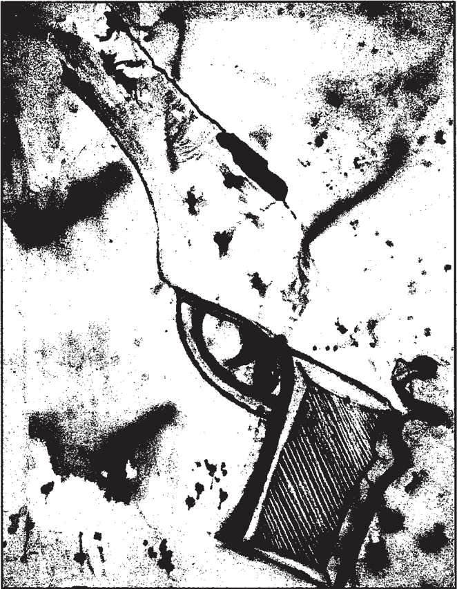 Map of Israel as the barrel of a gun illustrated by an Israeli high-school student
(Jewish Chronicle, 21 June 2002).
● The Great Toponymic Divide
When we want to specify a particular geographical feature, we may sometimes find several names available for it. Determining the ‘appropriate’ name for a feature comes with many cultural and political issues. “Apart from acknowledging
local sensitivities, we may also need to establish a balance between the name we ourselves recognize and the name as recognized in the locality itself, on the ground” (Woodman, 2012). Toponyms can generally be divided into two main
categories, endonyms and exonyms. Paul Woodman calls this division ‘the great toponymic divide’.
Endonyms are native geographical names written in the local language and script, the local population’s self-designated names for their surroundings. Suomi (SuomiFinland), Magyarország (MagyarországHungary), Ελλάδα (ΕλλάδαGreece) and Україна (УкраїнаUkraine) are all examples of endonyms. These names have not undergone any kind of transformation and thus preserve the correct
pronunciation. However, the use of local languages — and above all local scripts — presents challenges for non-native or otherwise unfamiliar users. Another challenge arises in cases where larger geographical features, like mountain
ranges or seas, are surrounded by several countries that all have their own unique name for the feature, in some cases also in different scripts (Dušek & Popelková, 2021).
Exonyms, on the other hand, are non-native names, established outside the local linguistic community. Maps employing exonyms are primarily targeted at ‘domestic’ users (i.e. users in a specific linguistic region). They are commonly
found in e.g. school atlases, where they represent a more accessible and easily comprehendible form of local names for the targeted users (Dušek & Popelková, 2021). Kööpenhamina (Finnish name for KøbenhavnCopenhagen), Laibach (German name for LjubljanaLjubljana) and
Venice (English name for VeneziaVenice) are examples of exonyms. Additionally, if a (large) geographical feature extends over more
than one country, each of those countries (and languages within those countries) might have a unique endonym for it. In such cases, instead of choosing one of the local endonyms, many languages have developed exonyms to refer to the
features in question.
Geographer Naftali Kadmon gives the example of “[t]he river starting in Germany under the endonym Donau and ending in the Black Sea as Dunaj
traverses eight countries and carries five different endonyms; hence, for simplicity, the English language uses the exonym Danube” (Kadmon, 2001).
A rather obvious disadvantage of this system is that it makes maps implicitly incomprehensible for users outside the designated linguistic community. Furthermore, exonyms are mainly established for places of greater
significance (countries, major cities, oceans, mountain ranges, etc.), meaning that most geographical features do not have a corresponding exonym.
As a sub-category of endonyms, I ought to mention endonyms written in the Latin (Roman) script. In these cases, names are romanized, i.e. converted from the local script into the Latin writing system, with the aim of constructing a
single unified form for all geographical names in order to avoid ambiguity and confusion. This system enjoys widespread international support and is promoted by the United Nations, which I will discuss more in detail in the next
section. Despite its success, this approach carries several disadvantages; Firstly, much like in the case of exonyms, it creates discrepancies between names on maps and their local forms and renders maps virtually useless for people
unfamiliar with the Latin script
Although the Latin script is the most widespread script in the world, there are regions, such as China and several Arab countries, where a large proportion of the population is not familiar of proficient in the
Latin script.
. Secondly, its preference for the Latin script is fundamentally Eurocentric; in many regions it creates associations to the linguistic mutilation projects carried out by European colonial empires, and it contributes profoundly
to the homogenization of the linguistic and cultural landscape (Dušek & Popelková, 2021).
Outside ‘the great toponymic divide’ we can find an additional, perhaps the most ‘linguistically neutral’, method — transcription based on pronunciation. Its main advantage is that information on local pronunciation of place names is
always available, and with a wide variety of official transcription systems, pronunciations can be preserved in their original form. Transcription is furthermore independent of the written form, which means that it is equally
applicable for phonemic, syllabic or logographic scripts — as well as for unwritten languages. The most widely used transcription system is the International Phonetic Alphabet (IPA)
The IPA is, however, not the only phonetic alphabet available. Others include the Americanist Phonetic Notation, the Uralic Phonetic Alphabet, Pinyin and the Arabic International Phonetic Alphabet.
, which you might have encountered in lexicons or on Wikipedia. The most significant drawback of the IPA is, as one might anticipate, its European origin; apart from a few Greek characters and a handful of newly created
characters, it is solely based on the Latin script — and therefore read from left to right (Dušek & Popelková, 2021). Thus, promoting the use of the IPA in map labeling would further enforce the dominant role of the Latin script.
Map of Israel as the barrel of a gun illustrated by an Israeli high-school student
(Jewish Chronicle, 21 June 2002).
● The Great Toponymic Divide
When we want to specify a particular geographical feature, we may sometimes find several names available for it. Determining the ‘appropriate’ name for a feature comes with many cultural and political issues. “Apart from acknowledging
local sensitivities, we may also need to establish a balance between the name we ourselves recognize and the name as recognized in the locality itself, on the ground” (Woodman, 2012). Toponyms can generally be divided into two main
categories, endonyms and exonyms. Paul Woodman calls this division ‘the great toponymic divide’.
Endonyms are native geographical names written in the local language and script, the local population’s self-designated names for their surroundings. Suomi (SuomiFinland), Magyarország (MagyarországHungary), Ελλάδα (ΕλλάδαGreece) and Україна (УкраїнаUkraine) are all examples of endonyms. These names have not undergone any kind of transformation and thus preserve the correct
pronunciation. However, the use of local languages — and above all local scripts — presents challenges for non-native or otherwise unfamiliar users. Another challenge arises in cases where larger geographical features, like mountain
ranges or seas, are surrounded by several countries that all have their own unique name for the feature, in some cases also in different scripts (Dušek & Popelková, 2021).
Exonyms, on the other hand, are non-native names, established outside the local linguistic community. Maps employing exonyms are primarily targeted at ‘domestic’ users (i.e. users in a specific linguistic region). They are commonly
found in e.g. school atlases, where they represent a more accessible and easily comprehendible form of local names for the targeted users (Dušek & Popelková, 2021). Kööpenhamina (Finnish name for KøbenhavnCopenhagen), Laibach (German name for LjubljanaLjubljana) and
Venice (English name for VeneziaVenice) are examples of exonyms. Additionally, if a (large) geographical feature extends over more
than one country, each of those countries (and languages within those countries) might have a unique endonym for it. In such cases, instead of choosing one of the local endonyms, many languages have developed exonyms to refer to the
features in question.
Geographer Naftali Kadmon gives the example of “[t]he river starting in Germany under the endonym Donau and ending in the Black Sea as Dunaj
traverses eight countries and carries five different endonyms; hence, for simplicity, the English language uses the exonym Danube” (Kadmon, 2001).
A rather obvious disadvantage of this system is that it makes maps implicitly incomprehensible for users outside the designated linguistic community. Furthermore, exonyms are mainly established for places of greater
significance (countries, major cities, oceans, mountain ranges, etc.), meaning that most geographical features do not have a corresponding exonym.
As a sub-category of endonyms, I ought to mention endonyms written in the Latin (Roman) script. In these cases, names are romanized, i.e. converted from the local script into the Latin writing system, with the aim of constructing a
single unified form for all geographical names in order to avoid ambiguity and confusion. This system enjoys widespread international support and is promoted by the United Nations, which I will discuss more in detail in the next
section. Despite its success, this approach carries several disadvantages; Firstly, much like in the case of exonyms, it creates discrepancies between names on maps and their local forms and renders maps virtually useless for people
unfamiliar with the Latin script
Although the Latin script is the most widespread script in the world, there are regions, such as China and several Arab countries, where a large proportion of the population is not familiar of proficient in the
Latin script.
. Secondly, its preference for the Latin script is fundamentally Eurocentric; in many regions it creates associations to the linguistic mutilation projects carried out by European colonial empires, and it contributes profoundly
to the homogenization of the linguistic and cultural landscape (Dušek & Popelková, 2021).
Outside ‘the great toponymic divide’ we can find an additional, perhaps the most ‘linguistically neutral’, method — transcription based on pronunciation. Its main advantage is that information on local pronunciation of place names is
always available, and with a wide variety of official transcription systems, pronunciations can be preserved in their original form. Transcription is furthermore independent of the written form, which means that it is equally
applicable for phonemic, syllabic or logographic scripts — as well as for unwritten languages. The most widely used transcription system is the International Phonetic Alphabet (IPA)
The IPA is, however, not the only phonetic alphabet available. Others include the Americanist Phonetic Notation, the Uralic Phonetic Alphabet, Pinyin and the Arabic International Phonetic Alphabet.
, which you might have encountered in lexicons or on Wikipedia. The most significant drawback of the IPA is, as one might anticipate, its European origin; apart from a few Greek characters and a handful of newly created
characters, it is solely based on the Latin script — and therefore read from left to right (Dušek & Popelková, 2021). Thus, promoting the use of the IPA in map labeling would further enforce the dominant role of the Latin script.
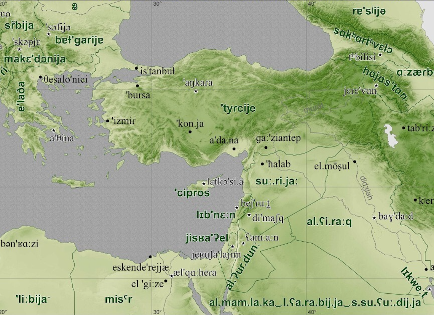
 A ‘linguistically neutral’ (although not grammatologically neutral) map with features described using the International Phonetic Alphabet. (Source: Dušek & Popelková)
● Tamed Dragon’s Teeth
There is a story in Greek mythology about Cadmus, a Prince of صورTyre, who sailed to ΒοιωτίαBoeotia in ΕλλάδαGreece
in search for his sister Europa. Upon arrival he encountered a fierce dragon. Cadmus slayed the dragon and sowed its teeth in the ground, which miraculously sprouted an army of men who started killing each other. Once the massacre was
over, five men remained, and they helped Cadmus build the city of ΘήβαThebes and conquer the tribes of ΕλλάδαGreece (Grimal, 1992). Along with barbaric tribes, Cadmus introduced literacy and the Phoenician letters
The Phoenician alphabet (c. 1050–150 BC) is also called the Early Linear script because it is an early development of the Proto- or Old Canaanite or Proto-Sinaitic script, into a linear, purely alphabetic
script, also marking the transfer from a multi-directional writing system, where a variety of writing directions occurred, to a regulated horizontal, right-to-left script.
into ΕλλάδαGreece. Unlike pre-alphabetic (pictographic) writing-systems, the alphabet was efficient and easy to learn, allowing the rise of empires and military bureaucracies, and the fall of priestly power (McLuhan, 1964).
This myth of the co-origins of literacy and the empire symbolizes the power, authority and violence embodied in the alphabet. Letters — the key to wisdom — are, in a way, a form of tamed dragon’s teeth — an agent of power. As Marshall
McLuhan explains in Understanding Media: “Languages are filled with testimony to the grasping, devouring power and precision of teeth. That the power of letters as agents of aggressive order and
precision should be expressed as extensions of the dragon's teeth is natural and fitting. Teeth are emphatically visual in their lineal order. Letters are not only like teeth visually, but their power to put teeth into the business of
empire-building is manifest in our Western history.” (McLuhan, 1964)
As (western) societies became more sophisticated, the alphabets used to write gained an increasingly phonetic form. Rather than pictures or ideas, as is the case in e.g. Egyptian hieroglyphs, letters came to represent syllables and
ultimately individual speech sounds — vowels and consonants — as is the case in the Latin script (Pater, 2016), which is today used by 70% of the world’s population (Pariona, 2019). Not all scripts are, however, alphabetic. Another
large cluster of writing systems, used from the Eastern Mediterranean to Southeast Asia, fall under the category of syllabic writing systems. These systems focus on the syllables rather than specific
letters. Within this category we find e.g. the Arabic and Hebrew scripts, which mainly utilize consonants, most of the vowels only being spoken. Hence, “knowing the Arabic script but not the language will allow you to produce only a
rough approximation of the sound value of a given word” (Collin, 2005). These “alphabetical differences” can create major challenges in translation.
● Transliteration and Homogenization
“Do you translate by eye or by ear?
Translation seeks faithfulness and accuracy and ends up always betraying either the letter of the text, its spirit, or its aesthetics. The original text is always already an impossible translation that renders translation
impossible.”
— Trinh T. Minh-ha in Surname Viet Given Name Nam (1989)
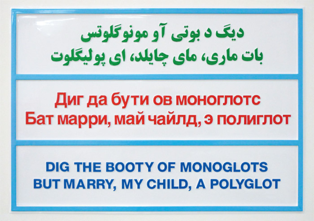
When two writing systems lack interlegibility, we resort to transliteration — the conversion of a string of letters to another string of letters, usually based on the phonetics of the original word (Josan & Lehan, 2010). The most
common practice of transliteration today is romanization — i.e. the transfer of non-Latin writing to the Latin script by means of an expanded Latin alphabet with the use of diacritical marks and letter combinations — mainly due to the
role of English as an imperial language and the ‘language of globalization’ — a “language of both oppression and opportunity” (Kharchenko, 2017). This notion of the English language
Although this is the case today, English didn’t become the most important language of diplomacy and international relations — lingua franca — until approximately the middle of the 20th-century, when the United States became the dominant global power following the Second World War. English as lingua franca was preceded by French, which in turn replaced Latin in the 17th-century (Weber, 1997).
being the key to modernization and Westernization,
has led many nations to switch to the Latin script. Notable examples are the cases of Việt NamVietnam (mid-17th-century), RomâniaRomania (1860s), ShqipëriAlbania (1908) and TürkiyeTurkey (1928).
A ‘linguistically neutral’ (although not grammatologically neutral) map with features described using the International Phonetic Alphabet. (Source: Dušek & Popelková)
● Tamed Dragon’s Teeth
There is a story in Greek mythology about Cadmus, a Prince of صورTyre, who sailed to ΒοιωτίαBoeotia in ΕλλάδαGreece
in search for his sister Europa. Upon arrival he encountered a fierce dragon. Cadmus slayed the dragon and sowed its teeth in the ground, which miraculously sprouted an army of men who started killing each other. Once the massacre was
over, five men remained, and they helped Cadmus build the city of ΘήβαThebes and conquer the tribes of ΕλλάδαGreece (Grimal, 1992). Along with barbaric tribes, Cadmus introduced literacy and the Phoenician letters
The Phoenician alphabet (c. 1050–150 BC) is also called the Early Linear script because it is an early development of the Proto- or Old Canaanite or Proto-Sinaitic script, into a linear, purely alphabetic
script, also marking the transfer from a multi-directional writing system, where a variety of writing directions occurred, to a regulated horizontal, right-to-left script.
into ΕλλάδαGreece. Unlike pre-alphabetic (pictographic) writing-systems, the alphabet was efficient and easy to learn, allowing the rise of empires and military bureaucracies, and the fall of priestly power (McLuhan, 1964).
This myth of the co-origins of literacy and the empire symbolizes the power, authority and violence embodied in the alphabet. Letters — the key to wisdom — are, in a way, a form of tamed dragon’s teeth — an agent of power. As Marshall
McLuhan explains in Understanding Media: “Languages are filled with testimony to the grasping, devouring power and precision of teeth. That the power of letters as agents of aggressive order and
precision should be expressed as extensions of the dragon's teeth is natural and fitting. Teeth are emphatically visual in their lineal order. Letters are not only like teeth visually, but their power to put teeth into the business of
empire-building is manifest in our Western history.” (McLuhan, 1964)
As (western) societies became more sophisticated, the alphabets used to write gained an increasingly phonetic form. Rather than pictures or ideas, as is the case in e.g. Egyptian hieroglyphs, letters came to represent syllables and
ultimately individual speech sounds — vowels and consonants — as is the case in the Latin script (Pater, 2016), which is today used by 70% of the world’s population (Pariona, 2019). Not all scripts are, however, alphabetic. Another
large cluster of writing systems, used from the Eastern Mediterranean to Southeast Asia, fall under the category of syllabic writing systems. These systems focus on the syllables rather than specific
letters. Within this category we find e.g. the Arabic and Hebrew scripts, which mainly utilize consonants, most of the vowels only being spoken. Hence, “knowing the Arabic script but not the language will allow you to produce only a
rough approximation of the sound value of a given word” (Collin, 2005). These “alphabetical differences” can create major challenges in translation.
● Transliteration and Homogenization
“Do you translate by eye or by ear?
Translation seeks faithfulness and accuracy and ends up always betraying either the letter of the text, its spirit, or its aesthetics. The original text is always already an impossible translation that renders translation
impossible.”
— Trinh T. Minh-ha in Surname Viet Given Name Nam (1989)
When two writing systems lack interlegibility, we resort to transliteration — the conversion of a string of letters to another string of letters, usually based on the phonetics of the original word (Josan & Lehan, 2010). The most
common practice of transliteration today is romanization — i.e. the transfer of non-Latin writing to the Latin script by means of an expanded Latin alphabet with the use of diacritical marks and letter combinations — mainly due to the
role of English as an imperial language and the ‘language of globalization’ — a “language of both oppression and opportunity” (Kharchenko, 2017). This notion of the English language
Although this is the case today, English didn’t become the most important language of diplomacy and international relations — lingua franca — until approximately the middle of the 20th-century, when the United States became the dominant global power following the Second World War. English as lingua franca was preceded by French, which in turn replaced Latin in the 17th-century (Weber, 1997).
being the key to modernization and Westernization,
has led many nations to switch to the Latin script. Notable examples are the cases of Việt NamVietnam (mid-17th-century), RomâniaRomania (1860s), ShqipëriAlbania (1908) and TürkiyeTurkey (1928).
 Dig the Booty by Slavs and Tatars (2009) features a transliteration of an aphorism across the Latin, Cyrillic and and Perso-Arabic scripts in homage to the vicissitudes of the Azeri alphabet which changed 3 times over the past
century: from Arabic to Latin in 1929, from Latin to Cyrillic in 1939, only to go back to Latin in 1991. (Source: Slavs and Tatars)
In the 1920s and 30s, the CCCPUSSR initiated a campaign to replace the 72 traditional writing systems within the union with systems based on the Latin script. Between 1923 and 1939, Latin alphabets were created for 50 of these
languages. The campaign did, however, fall short, and in 1936 a new campaign began with the aim of converting the languages of the USSR to Cyrillic instead. This project was largely completed four years later. Following the fall of
the CCCPUSSR in 1991, a trend of once again converting to the Latin script emerged among post-Soviet nations in the name of modernization and disassociation with the Russian intellectual and cultural sphere. AzərbaycanAzerbaijan, followed by OʻzbekistonUzbekistan and TürkmenistanTurkmenistan, as well as MoldovaMoldova, all made the switch in the 1990s. In 2017, the
President of ҚазақстанKazakhstan Nursultan Nazarbayev announced that a switch to the Latin script, a symbolic move to calcify the nation’s
independence, is being prepared; marking the third script change in ҚазақстанKazakhstan within 100 years
Kazakh, a Turkic language, used to be written in Arabic until the 1920s when the Soviet Union briefly introduced the Latin alphabet before eventually replacing it by the Cyrillic one in 1940 (The Guardian,
2017).
. The project is set to be completed by 2025 (The Guardian, 2017; Haddad, 2017). The announcement received widespread criticism, especially after the government revealed the suggested new Latin alphabet known as the ‘apostrophe
alphabet’ (the alphabet features 23 Latin letters, along with 9 specific Kazakh sounds, which were identified by placing an apostrophe after the letter). A number of prominent Kazakh-speaking academics and professors argued that “the
move would complicate the writing system and only diminish the status of the Kazakh language in the country.” Concerns were also raised about the alphabet requiring multiple apostrophes in one word to separate Kazakh-specific sounds,
such as in the word s’yg’ys’, meaning east (Kudaibergenova, 2017).
Dig the Booty by Slavs and Tatars (2009) features a transliteration of an aphorism across the Latin, Cyrillic and and Perso-Arabic scripts in homage to the vicissitudes of the Azeri alphabet which changed 3 times over the past
century: from Arabic to Latin in 1929, from Latin to Cyrillic in 1939, only to go back to Latin in 1991. (Source: Slavs and Tatars)
In the 1920s and 30s, the CCCPUSSR initiated a campaign to replace the 72 traditional writing systems within the union with systems based on the Latin script. Between 1923 and 1939, Latin alphabets were created for 50 of these
languages. The campaign did, however, fall short, and in 1936 a new campaign began with the aim of converting the languages of the USSR to Cyrillic instead. This project was largely completed four years later. Following the fall of
the CCCPUSSR in 1991, a trend of once again converting to the Latin script emerged among post-Soviet nations in the name of modernization and disassociation with the Russian intellectual and cultural sphere. AzərbaycanAzerbaijan, followed by OʻzbekistonUzbekistan and TürkmenistanTurkmenistan, as well as MoldovaMoldova, all made the switch in the 1990s. In 2017, the
President of ҚазақстанKazakhstan Nursultan Nazarbayev announced that a switch to the Latin script, a symbolic move to calcify the nation’s
independence, is being prepared; marking the third script change in ҚазақстанKazakhstan within 100 years
Kazakh, a Turkic language, used to be written in Arabic until the 1920s when the Soviet Union briefly introduced the Latin alphabet before eventually replacing it by the Cyrillic one in 1940 (The Guardian,
2017).
. The project is set to be completed by 2025 (The Guardian, 2017; Haddad, 2017). The announcement received widespread criticism, especially after the government revealed the suggested new Latin alphabet known as the ‘apostrophe
alphabet’ (the alphabet features 23 Latin letters, along with 9 specific Kazakh sounds, which were identified by placing an apostrophe after the letter). A number of prominent Kazakh-speaking academics and professors argued that “the
move would complicate the writing system and only diminish the status of the Kazakh language in the country.” Concerns were also raised about the alphabet requiring multiple apostrophes in one word to separate Kazakh-specific sounds,
such as in the word s’yg’ys’, meaning east (Kudaibergenova, 2017).
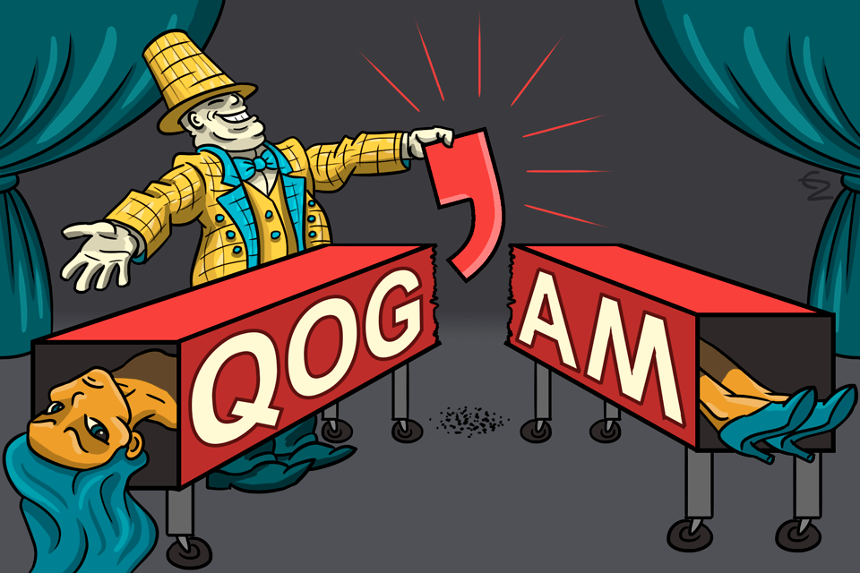 Қоғам – “society” in Kazakh – is divided. The word in Latin alphabet would be spelled as “qog’am”
literally dividing it into two parts. Illustration by Erden Zikibay
Transliteration of toponyms is of paramount importance in today’s society when we consider the need to compile various geographical maps, atlases, archival documents, telephone and address books, geographical and historical essays,
travel guides, GPS systems, Google Maps, journalism and media, reference pointers and signs, etc., in foreign languages (Sarsembayeva & Agabekova, 2022). This need raises questions about standardization and homogenization of toponyms
at an international level, to the extent that it is addressed at the UN level.
In 1959, the Economic and Social Council (ECOSOC) facilitated the formation of a small group of experts who aimed to provide technical advice on standardizing geographical names at both national and international levels. This meeting
led to the establishment of the United Nations Conferences on the Standardization of Geographical Names (UNCSGN) and the United Nations Group of Experts on Geographical Names (UNGEGN). The purpose of these entities is to “establish
usable and consistent written forms of toponyms and their applications throughout the world.” The group believes that standardizing geographical names is necessary for modern society as it leads to more accurate administration and
communication, as well as time and cost savings in various sectors such as government, industry, commerce, and education (UNGEGN, 2006). In practice, this standardization process takes shape as an enterprise of romanization; the Latin
script has been designated as the sole global standard for toponyms and a standard transliteration system has been established for non-Latin scripts — subsequently blatantly marginalizing them.
We thus come to understand that linguicism and technocratic homogenization do not only happen on a national, but also an international level; And furthermore, that these acts do not only occur in hegemonic contexts, but also as a
consequence of a desire for Westernization. In the next chapter we will look into forces countering these developments and assess alternative methods for conventional graphic representation in cartography by considering a wider
sensory spectrum, namely the influence of speech.
● Infrapolitics in Geography
“When the great lord passes, the wise peasant bows deeply and silently farts”
— Ethiopian Proverb
Resistance within geography is conventionally conceptualized as organized collective opposition to particular configurations of power relations, such as strikes, protests and riots. Even though they might be considered unremarkable,
it is important to also recognize the less grandiose oppositional acts of those who lack the backing of institutions — the ‘quiet’ acts that take place in everyday practices. Italian philosopher Giorgio Agamben explores the idea of
‘bare life’ and the ways in which power operates on bodies through the creation of exclusionary zones and the suspension of rights. He argues that acts of resistance, including those that are subtle and
mundane, can serve to challenge and subvert dominant power structures and create spaces of potentiality and freedom (Agamben, 1998; 2014). To further conceptualize these acts, James Scott (1990) coined the compelling term infrapolitics. For some, these subliminal acts of resistance do not aim overcoming, but rather withstanding configurations of power and
rendering them inoperative.
An example of this is the Nassar family, who reside on a hilltop farm in the Palestinian village of بتيرBattir in the occupied الضفة الغربيةWest Bank, who have been fighting for their land rights for over 25 years. Despite having their farm declared as “state land”
by Israeli officials and facing obstacles such as denied building permits and transportation barriers, the family has chosen to resist non-violently through various means. These include running volunteer and community projects, summer
camps for children, and selling products made from their crops. When faced with challenges such as a lack of building permits or utilities, they found creative solutions such as building premises underground and using solar panels.
They also utilize social networks to keep their farming activities alive despite the pressures from the colonial authorities. This form of resistance emphasizes remaining open, avoiding dependencies, and maintaining a non-violent way
of life (Joronen, 2016).
Қоғам – “society” in Kazakh – is divided. The word in Latin alphabet would be spelled as “qog’am”
literally dividing it into two parts. Illustration by Erden Zikibay
Transliteration of toponyms is of paramount importance in today’s society when we consider the need to compile various geographical maps, atlases, archival documents, telephone and address books, geographical and historical essays,
travel guides, GPS systems, Google Maps, journalism and media, reference pointers and signs, etc., in foreign languages (Sarsembayeva & Agabekova, 2022). This need raises questions about standardization and homogenization of toponyms
at an international level, to the extent that it is addressed at the UN level.
In 1959, the Economic and Social Council (ECOSOC) facilitated the formation of a small group of experts who aimed to provide technical advice on standardizing geographical names at both national and international levels. This meeting
led to the establishment of the United Nations Conferences on the Standardization of Geographical Names (UNCSGN) and the United Nations Group of Experts on Geographical Names (UNGEGN). The purpose of these entities is to “establish
usable and consistent written forms of toponyms and their applications throughout the world.” The group believes that standardizing geographical names is necessary for modern society as it leads to more accurate administration and
communication, as well as time and cost savings in various sectors such as government, industry, commerce, and education (UNGEGN, 2006). In practice, this standardization process takes shape as an enterprise of romanization; the Latin
script has been designated as the sole global standard for toponyms and a standard transliteration system has been established for non-Latin scripts — subsequently blatantly marginalizing them.
We thus come to understand that linguicism and technocratic homogenization do not only happen on a national, but also an international level; And furthermore, that these acts do not only occur in hegemonic contexts, but also as a
consequence of a desire for Westernization. In the next chapter we will look into forces countering these developments and assess alternative methods for conventional graphic representation in cartography by considering a wider
sensory spectrum, namely the influence of speech.
● Infrapolitics in Geography
“When the great lord passes, the wise peasant bows deeply and silently farts”
— Ethiopian Proverb
Resistance within geography is conventionally conceptualized as organized collective opposition to particular configurations of power relations, such as strikes, protests and riots. Even though they might be considered unremarkable,
it is important to also recognize the less grandiose oppositional acts of those who lack the backing of institutions — the ‘quiet’ acts that take place in everyday practices. Italian philosopher Giorgio Agamben explores the idea of
‘bare life’ and the ways in which power operates on bodies through the creation of exclusionary zones and the suspension of rights. He argues that acts of resistance, including those that are subtle and
mundane, can serve to challenge and subvert dominant power structures and create spaces of potentiality and freedom (Agamben, 1998; 2014). To further conceptualize these acts, James Scott (1990) coined the compelling term infrapolitics. For some, these subliminal acts of resistance do not aim overcoming, but rather withstanding configurations of power and
rendering them inoperative.
An example of this is the Nassar family, who reside on a hilltop farm in the Palestinian village of بتيرBattir in the occupied الضفة الغربيةWest Bank, who have been fighting for their land rights for over 25 years. Despite having their farm declared as “state land”
by Israeli officials and facing obstacles such as denied building permits and transportation barriers, the family has chosen to resist non-violently through various means. These include running volunteer and community projects, summer
camps for children, and selling products made from their crops. When faced with challenges such as a lack of building permits or utilities, they found creative solutions such as building premises underground and using solar panels.
They also utilize social networks to keep their farming activities alive despite the pressures from the colonial authorities. This form of resistance emphasizes remaining open, avoiding dependencies, and maintaining a non-violent way
of life (Joronen, 2016).
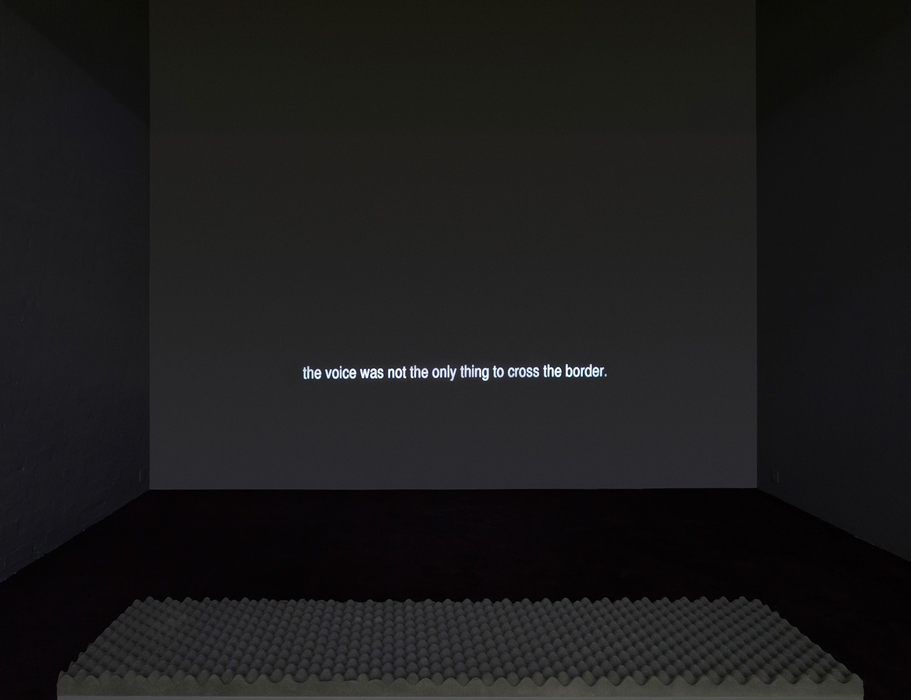
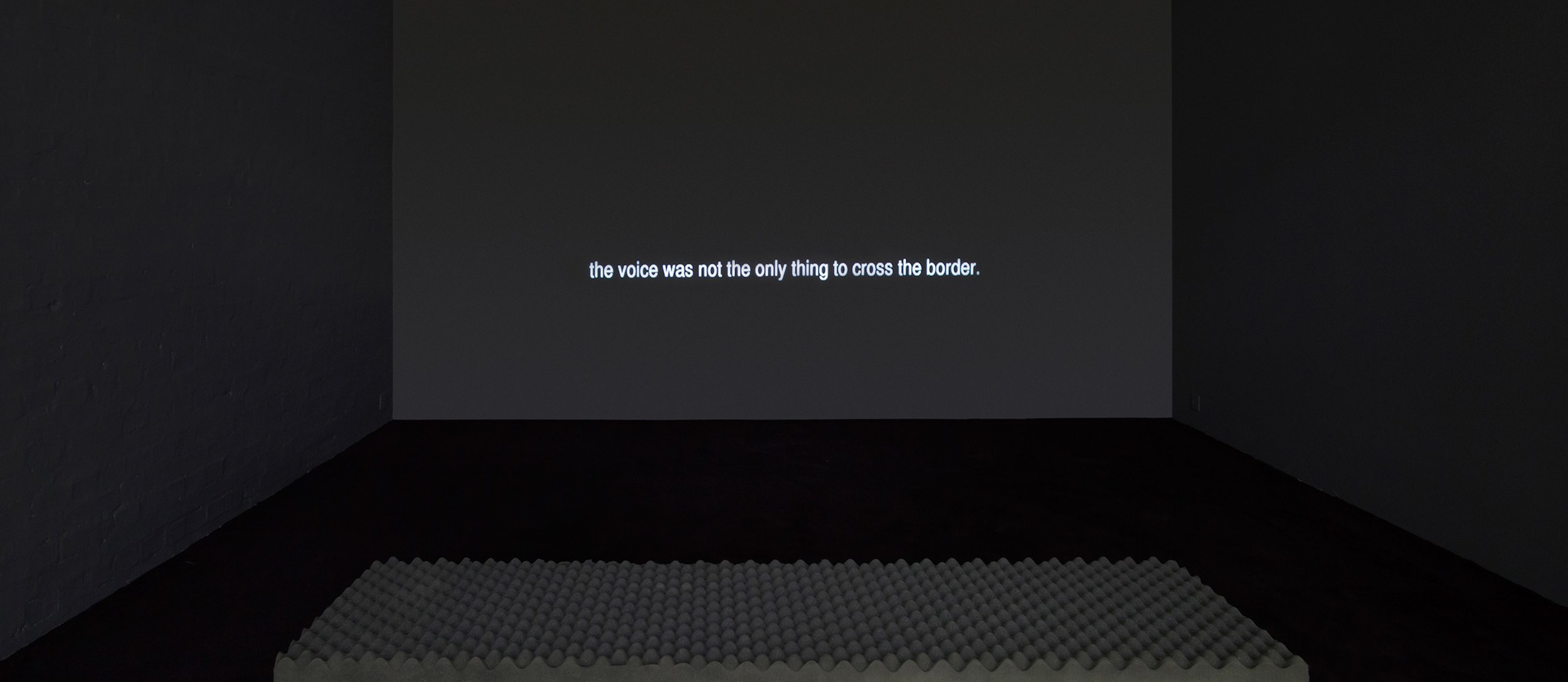 Language Gulf in the Shouting Valley by Lawrence Abu Hamdan (2013) as part of the exhibition Meeting Points 7 – Ten Thousand Wiles and a Hundred Thousand
Tricks at the Museum of Contemporary Art Antwerp, Belgium. (Source: Lawrence Abu Hamdan)
During the Six-Day War
Fought between Israel and the joined forces of Egypt, Syria and Jordan from 5 to 10 of June 1967. As a result of Israel’s victory, it annexed the Golan Heights from Syria, the West Bank and East Jerusalem from
Jordan and the Gaza Strip and the Sinai Peninsula from Egypt.
in 1967, יִשְׂרָאֵלIsrael annexed هَضْبَةُ الْجَوْلَانِThe Golan Heights from سُورِيَةSyria, resulting in
the drawing of a new border which geographically divided the local Druze
An Arabic-speaking ethnoreligious group, primarily located in Lebanon, Syria and Israel.
communities and families. On the Syrian side of the ceasefire line lies a place known as the ‘Shouting Valley’, a topographic feature which creates an acoustic leak and amplifies sound traveling
across the border, which is used by the communities on each side to communicate with each other (Abu Hamdan, 2017). The power of these voices defying an imposed geographical boundary is poignantly encapsulated in both Smadar Dreyfus’
installation Mother’s Day (2006–08) and Lawrence Abu Hamdan’s audio essay Language Gulf in the Shouting Valley (2013).
● Toponymic Resistance
Place names do not only exist as toponymic inscriptions in written form; their main form of existence lie in the spectrum of speech. Even though place names in many cases have prevailing official forms or generally enjoy widespread
agreement, “the way the name is pronounced reflects, and contributes to, the constitution of imagined communities […] and can thus be deployed to assert a politics of representation” (Berg & Kearns,
2002). In other words, speech can function as a creative and assertive act, independent of forces of hegemony and dominant discourses, that creates alternative realities. In this section we will consider ways in which groups
constructed as the Other resist official, top-down naming practices by creating alternative toponomies.
In The Practice of Everyday Life, Michel de Certeau speaks of everyday practices, such as walking or speaking, as diverse, creative, small-scale tactics — “an art of the weak” (de Certeau, 1984). He
makes a clear distinction between strategies and tactics — the former being the framework of the dominant institutions to assert objectives, and the latter being individual
everyday acts (of resistance) and ways to diverge from the conventions prescribed by the hegemon. Berg and Kearns (2002) argue that “[p]lace names are publicly pronounced, and there is thus scope to not only identify a point on the map, but also to make a point through (metaphorically) mapping out one’s politics of place in speech”, and suggest that these acts of resistance can
occur on at least two levels: through the creation and deployment of alternative (indigenous) toponyms, and the performative act of using alternative pronunciations for official names.
Philosopher Judith Butler defines performativity as “the reiterative and citational practice by which discourse produces the effects that it names” (Butler, 1993). Drawing on this conceptualization, we can understand the specific
pronunciation of names, not only as a descriptive act, but also as a constitutive act — one that can carry particular meanings or political agendas. Pronouncing a place
name also involves a process of selection: one either abides to the prescribed practices — and in doing so, constructs not only a place-name, but also a position for the Self within the context hegemonic
socio-spatial relations — or chooses alternative phonetic emphases and intonations and subsequently disrupts and interrogates the overarching structures one exists within (Berg & Kearns, 2002). The work of Trinh T. Minh-ha can also be
relevant to this discussion on the performative nature of place names. Minh-ha's concept of ‘writing-resistance’ highlights how the act of naming can be a form of resistance against dominant cultural discourses and colonial practices.
In her book Woman, Native, Other: Writing Postcoloniality and Feminism, Minh-ha explores the politics of representation and the construction of identity through language, arguing that naming is a
political act that carries cultural and historical significance. In this context, Minh-ha's work adds another dimension to the argument that naming can serve as a creative and assertive act of resistance (Minh-ha, 1989). Furthermore,
by forming alliances within and across disenfranchised communities, the affect of resistance can gain momentum, more solidarity and voices and exposure to the global community.
Language Gulf in the Shouting Valley by Lawrence Abu Hamdan (2013) as part of the exhibition Meeting Points 7 – Ten Thousand Wiles and a Hundred Thousand
Tricks at the Museum of Contemporary Art Antwerp, Belgium. (Source: Lawrence Abu Hamdan)
During the Six-Day War
Fought between Israel and the joined forces of Egypt, Syria and Jordan from 5 to 10 of June 1967. As a result of Israel’s victory, it annexed the Golan Heights from Syria, the West Bank and East Jerusalem from
Jordan and the Gaza Strip and the Sinai Peninsula from Egypt.
in 1967, יִשְׂרָאֵלIsrael annexed هَضْبَةُ الْجَوْلَانِThe Golan Heights from سُورِيَةSyria, resulting in
the drawing of a new border which geographically divided the local Druze
An Arabic-speaking ethnoreligious group, primarily located in Lebanon, Syria and Israel.
communities and families. On the Syrian side of the ceasefire line lies a place known as the ‘Shouting Valley’, a topographic feature which creates an acoustic leak and amplifies sound traveling
across the border, which is used by the communities on each side to communicate with each other (Abu Hamdan, 2017). The power of these voices defying an imposed geographical boundary is poignantly encapsulated in both Smadar Dreyfus’
installation Mother’s Day (2006–08) and Lawrence Abu Hamdan’s audio essay Language Gulf in the Shouting Valley (2013).
● Toponymic Resistance
Place names do not only exist as toponymic inscriptions in written form; their main form of existence lie in the spectrum of speech. Even though place names in many cases have prevailing official forms or generally enjoy widespread
agreement, “the way the name is pronounced reflects, and contributes to, the constitution of imagined communities […] and can thus be deployed to assert a politics of representation” (Berg & Kearns,
2002). In other words, speech can function as a creative and assertive act, independent of forces of hegemony and dominant discourses, that creates alternative realities. In this section we will consider ways in which groups
constructed as the Other resist official, top-down naming practices by creating alternative toponomies.
In The Practice of Everyday Life, Michel de Certeau speaks of everyday practices, such as walking or speaking, as diverse, creative, small-scale tactics — “an art of the weak” (de Certeau, 1984). He
makes a clear distinction between strategies and tactics — the former being the framework of the dominant institutions to assert objectives, and the latter being individual
everyday acts (of resistance) and ways to diverge from the conventions prescribed by the hegemon. Berg and Kearns (2002) argue that “[p]lace names are publicly pronounced, and there is thus scope to not only identify a point on the map, but also to make a point through (metaphorically) mapping out one’s politics of place in speech”, and suggest that these acts of resistance can
occur on at least two levels: through the creation and deployment of alternative (indigenous) toponyms, and the performative act of using alternative pronunciations for official names.
Philosopher Judith Butler defines performativity as “the reiterative and citational practice by which discourse produces the effects that it names” (Butler, 1993). Drawing on this conceptualization, we can understand the specific
pronunciation of names, not only as a descriptive act, but also as a constitutive act — one that can carry particular meanings or political agendas. Pronouncing a place
name also involves a process of selection: one either abides to the prescribed practices — and in doing so, constructs not only a place-name, but also a position for the Self within the context hegemonic
socio-spatial relations — or chooses alternative phonetic emphases and intonations and subsequently disrupts and interrogates the overarching structures one exists within (Berg & Kearns, 2002). The work of Trinh T. Minh-ha can also be
relevant to this discussion on the performative nature of place names. Minh-ha's concept of ‘writing-resistance’ highlights how the act of naming can be a form of resistance against dominant cultural discourses and colonial practices.
In her book Woman, Native, Other: Writing Postcoloniality and Feminism, Minh-ha explores the politics of representation and the construction of identity through language, arguing that naming is a
political act that carries cultural and historical significance. In this context, Minh-ha's work adds another dimension to the argument that naming can serve as a creative and assertive act of resistance (Minh-ha, 1989). Furthermore,
by forming alliances within and across disenfranchised communities, the affect of resistance can gain momentum, more solidarity and voices and exposure to the global community.
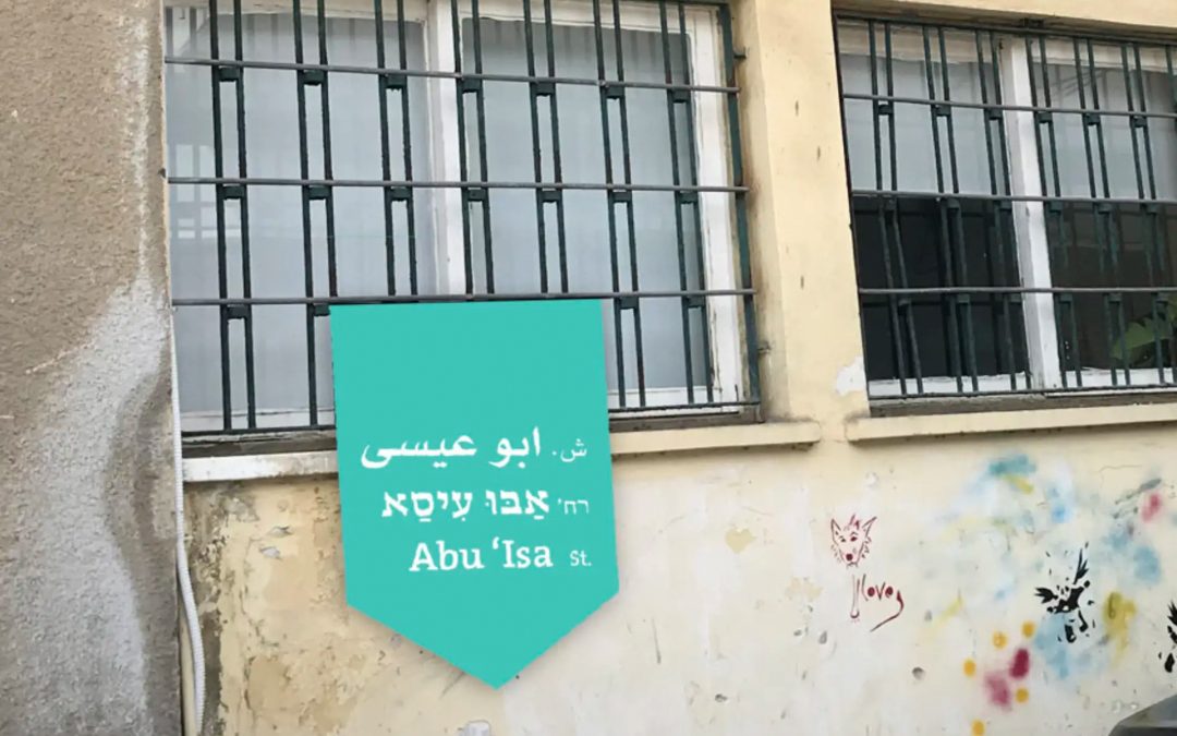 A planned new sign with the historic Arabic name of a street in Jaffa, next to the current street sign. (Source: Nawal Arafat)
One of the most active arenas for challenging Israeli naming traditions is the city of يَافَاJaffa. Rather than taking a militant approach and trying to cancel or erase current
names, a group of local women — namely Rachel Hagigi, Shani Egozin and Nawal Arafat — launched the Shawari’a Yafa (Streets of يَافَاJaffa) project, which aims to connect the city’s various communities, including Jewish ones, by giving
historical street names a shared presence in the public space. Due to strict policies by the mayor of תֵּל־אָבִיב-יָפוֹTel-Aviv-Jaffa and the municipality’s naming committee (which doesn’t have a single Arab member), hanging additional signs next to
existing street signs was not a legal option. Instead they decided to create small, pointed banners and persuaded homeowners to hang them from their balconies and windows facing the streets (Zandberg, 2022).
Despite the intense efforts by the Zionists authorities to overwrite Arabic place names that clash with Israeli ideology, many traditional names have been preserved through oral traditions, to the extent that they are even
acknowledged on a municipal level. The persistence of these toponyms in such a hostile environment can to some extent be understood through what Laura Kostanski calls toponymic attachment — “a symbolic
relationship that people form which can help in transmitting meanings to a place” (Kostanski, 2009). As mentioned in Chapter 1, the Hebraization project of the toponymic landscape gained unprecedented momentum following the ethnic
cleansing of 1948. Interestingly, archives from the القُدسJerusalem municipality reveal a stubborn reluctance
by the local authorities to abide to the imposed policies, obstructing the renaming of these areas until 1958 by continually formulating excuses for the delay (Socquet-Juglard, 2022). In a letter to the National Naming Committee in
1957, the Deputy Mayor of القُدسJerusalem writes: “[…] you will understand that I am not enthusiastic about proposals to give neighbourhoods new names instead of their historical names, which mirror the fine history of new القُدسJerusalem. […]
Every generation should know that القُدسJerusalem had a non-Jewish period […]” (Aderet, 2011). This ten-year lapse was manifestly enough time for the Arabic toponyms to be entrenched in the mental and physical maps of the new Jewish
settlers residing in القُدسJerusalem. In other words, the settlers became dependent on these names “to express and transmit not only the identity of the place they live, but also, indirectly, their own collective identity” (Socquet-Juglard,
2022). This toponymic attachment forced the القُدسJerusalem Municipality to acknowledge the Arabic names alongside the official Hebrew names, not only on road signs, but also in official maps and documents. The persistence of these Arabic
toponyms compellingly confirms the strength of practices versus policies.
● Conclusion
In this thesis I have attempted, through a decolonial lens, to offer an overview of the
geopolitical affects of toponymic inscription on a national and transnational level. By
examining the ideological strategies involved in Zionist nation-building, we have come
to understand that the socio-spatial practice of place naming can function as a powerful
politico-territorial instrument for spatial and cultural domination, primarily by means
of linguistic dispossession and memoricide. A closer look at various romanization enterprises
revealed that these practices not only take shape in hegemonic contexts but
also as a consequence of a desire for modernization. The closing section highlights the
importance of recognizing and valuing the subliminal forms of resistance that can challenge
and subvert dominant power structures and create spaces of potentiality and
freedom.
Although the examples given in this text are mostly focused on the historical
region of فلسطينPalestine, it is important to realize that these hegemonic acts are, and have
been, practiced in virtually every corner of the earth. The analytical framework presented
and applied here can hopefully serve as a starting point for further research on
the topic of toponymicide in other regions. By examining the ways in which geography,
and cartography in particular, is entangled with politics and power, we can perhaps
begin to imagine new ways of representing space that are more inclusive and just.
A planned new sign with the historic Arabic name of a street in Jaffa, next to the current street sign. (Source: Nawal Arafat)
One of the most active arenas for challenging Israeli naming traditions is the city of يَافَاJaffa. Rather than taking a militant approach and trying to cancel or erase current
names, a group of local women — namely Rachel Hagigi, Shani Egozin and Nawal Arafat — launched the Shawari’a Yafa (Streets of يَافَاJaffa) project, which aims to connect the city’s various communities, including Jewish ones, by giving
historical street names a shared presence in the public space. Due to strict policies by the mayor of תֵּל־אָבִיב-יָפוֹTel-Aviv-Jaffa and the municipality’s naming committee (which doesn’t have a single Arab member), hanging additional signs next to
existing street signs was not a legal option. Instead they decided to create small, pointed banners and persuaded homeowners to hang them from their balconies and windows facing the streets (Zandberg, 2022).
Despite the intense efforts by the Zionists authorities to overwrite Arabic place names that clash with Israeli ideology, many traditional names have been preserved through oral traditions, to the extent that they are even
acknowledged on a municipal level. The persistence of these toponyms in such a hostile environment can to some extent be understood through what Laura Kostanski calls toponymic attachment — “a symbolic
relationship that people form which can help in transmitting meanings to a place” (Kostanski, 2009). As mentioned in Chapter 1, the Hebraization project of the toponymic landscape gained unprecedented momentum following the ethnic
cleansing of 1948. Interestingly, archives from the القُدسJerusalem municipality reveal a stubborn reluctance
by the local authorities to abide to the imposed policies, obstructing the renaming of these areas until 1958 by continually formulating excuses for the delay (Socquet-Juglard, 2022). In a letter to the National Naming Committee in
1957, the Deputy Mayor of القُدسJerusalem writes: “[…] you will understand that I am not enthusiastic about proposals to give neighbourhoods new names instead of their historical names, which mirror the fine history of new القُدسJerusalem. […]
Every generation should know that القُدسJerusalem had a non-Jewish period […]” (Aderet, 2011). This ten-year lapse was manifestly enough time for the Arabic toponyms to be entrenched in the mental and physical maps of the new Jewish
settlers residing in القُدسJerusalem. In other words, the settlers became dependent on these names “to express and transmit not only the identity of the place they live, but also, indirectly, their own collective identity” (Socquet-Juglard,
2022). This toponymic attachment forced the القُدسJerusalem Municipality to acknowledge the Arabic names alongside the official Hebrew names, not only on road signs, but also in official maps and documents. The persistence of these Arabic
toponyms compellingly confirms the strength of practices versus policies.
● Conclusion
In this thesis I have attempted, through a decolonial lens, to offer an overview of the
geopolitical affects of toponymic inscription on a national and transnational level. By
examining the ideological strategies involved in Zionist nation-building, we have come
to understand that the socio-spatial practice of place naming can function as a powerful
politico-territorial instrument for spatial and cultural domination, primarily by means
of linguistic dispossession and memoricide. A closer look at various romanization enterprises
revealed that these practices not only take shape in hegemonic contexts but
also as a consequence of a desire for modernization. The closing section highlights the
importance of recognizing and valuing the subliminal forms of resistance that can challenge
and subvert dominant power structures and create spaces of potentiality and
freedom.
Although the examples given in this text are mostly focused on the historical
region of فلسطينPalestine, it is important to realize that these hegemonic acts are, and have
been, practiced in virtually every corner of the earth. The analytical framework presented
and applied here can hopefully serve as a starting point for further research on
the topic of toponymicide in other regions. By examining the ways in which geography,
and cartography in particular, is entangled with politics and power, we can perhaps
begin to imagine new ways of representing space that are more inclusive and just.
© Samuel Salminen, 2023 BA Graphic Design Royal Academy of Art, The Hague samuelsalminen.com Supervised by Prof. Füsun Türetken